
Landforms resulting from glacial erosion

- A cirque (corrie) is a steep sided rock basin, semi-circular in plan cut into valley heads and mountain Many are very small but some have back walls hundreds of metres high.
- Cirques usually develop from nivation hollows. Through the process of nivation, intensive shattering of highland slopes tend to produce depressions or pre-glacial hollows where ice accumulates.
- er freezes in the hollows and thaws or melts. There is consequently expansion and contraction that breaks the rock through the process of plucking.
- The nivation hollows are widened by not only plucking but also abrasion which is the wearing process of the hollow using the materials embedded in ice.
- The back walls of the hollow a.re steepened by back wall recession and it is deepened by basal sapping or rotation slipping of ice in the mountain hollow.
- Debris is removed from the hollow by solifluction; creating a semi-circular basin known as a cirque.
- The depression may later be filled with water to form lakes called tarns. Examples include those occupied by Lac du Speke, Lac Gris, Lac Catherine on Mt Rwenzori, Teleki tarn on Mt Kenya
Illustration of a cirque

2. A pyramidal peak
This is a sharp rock pinnacle which is steep sided surrounded by a system of radiating arêtes.
- It is formed from glacial erosion where cirques are first formed and the back wall recession of two or more cirques developing into the mountain head creates a sharp rock pinnacle protruding above the ice through a system of radiating arêtes.
- Since pyramidal peaks develop from radiating arêtes, which in tum develop from cirques then processes of plucking and abrasion are important in their
- Examples include margherita peak on mountain

3. An arête is a narrow step sided rocky ridge separating two cirques.

It results from the glacial erosional process of plucking and abrasion which lead to the formation of cirques The back wall recession of two adjacent cirques leads to the formation sharp ‘knife-like ridge called an arête separating two cirques. Examples are found on the foothills of Mt Rwenzori, one radiating into Bujuku Valley.
4. Glacial trough: This is a broad bottom and steep sided U- shaped valley,
It is formed when a river valley is filled with glacier. Plucking and abrasion help to deepen and widen the depression by vertical and lateral erosion
Examples include Bujuku and Mobuku valleys on Mt Rwenzori, Gorges valley on Mt Kenya and Karanga valley on Mt Kilimanjaro.

5. Hanging valleys. These are tributary valleys above the main valley that descend steeply into the main valley.
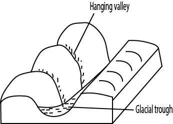
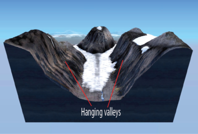
They generally form when glacier ice deeply erodes a main or trunk valley, leaving tributary valleys literally hanging far above the main valley floor. Tributary valleys can be seen leading to Mobuku and Bujuku on Mt Rwenzori
6. Rock steps. These are rock projections in U-shaped valley .They are formed as a result of variation in rock resistance .
Hare rocks resist erosion leading to rock projections in glacial trough
7. Rock Basins. These are circular depressions in U- shaped valleys. These are formed due to unequal power of erosion due to varying thickness of ice and variation in rock resistance .They are formed where there are soft /weak/jointed rocks on floor of U- shaped valley. Examples of rock basins include those occupied by Carr lakes on Mt Kenya.

8. Roche moutennee This is a gentle sloping mass of rock on upstream side and steep irregular on downstream side.

It is formed when the upstream side is smoothened by abrasion and the downstream side is affected by plucking leading to sleep jagged slope. Roche Moutennee can be seen in Mobuku valley on Mt Rwenzori and in gorges valley on Mt Kenya.
9. Crag and Tail. This is a mass of resistant rock outcrop, steep on the up – stream side which protects the soft rocks on the leeward slope. The eroded material is deposited down stream to form an elongated tail.

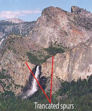
10. Truncated spurs. These are spurs with steep edges ending in the valley.
They are formed when former interlocking spurs are affected by plucking during glacial erosion to leave steep cliff-like valley sides
I learned something new today. Thank you! Home Improvement
You have a knack for making things clear. Transfer Latest
Achieve hassle-free enrollment with MBBS Admission Through Management/Nri Quota in Tamil Nadu.
Unlock special offers using the Raja Luck Invite Code.
Get exclusive lottery benefits with the powerful 82 Lottery Invite Code.
Receive customized game suggestions on the 82 Lottery App.