 in East Africa")
Physical geography Chapter 12: Climatology (weather) in East Africa

Climatology is the study of the atmosphere and weather patterns over time. This field of science focuses on recording and analyzing weather patterns throughout the world and understanding the atmospheric conditions that cause them.
Weather
Weathers refers to the atmospheric conditions of a given place for a short period of time e.g. one hour or one day. Weather elements are temperature, rainfall, humidity, sunshine, speed of wind, direction of wind, atmospheric pressure, etc. weather can be descried as rainy, windy, foggy, sunny etc. and these conditions vary from time to time.
Temperature
Temperature is the amount of sensible heat or cold within the atmosphere. The main source of heat affecting the atmosphere and the earth’s surface is the solar radiation. This culminates into differences into temperatures. Temperature is measured in degree Celsius or degree Fahrenheit (0F) using a thermometer.
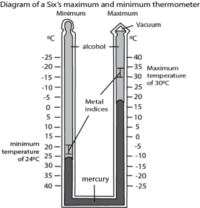
- Six’s Maximum and Minimum thermometer is a U shaped parallel tube made up of glass. One side registers the maximum temperature and the other side records the minimum temperature.
- The bend at the bottom of the thermometer contains mercury which moves up or down based on the expansion and contraction of alcohol.
- When the temperature rises, the alcohol expands and pushes the mercury up the maximum column. This also pushes the mercury down in the minimum column.
- Similarly, when the temperature falls, the alcohol contracts and pulls the mercury up in the minimum column resulting in a fall of mercury in the maximum column.
- The steel indexes are located on the surface of mercury. They move along with the flow of mercury up and down.
- When the temperature reaches its maximum and minimum limits, the metal indexes remain at that place. This helps in recording the maximum and minimum temperatures of the day.
- The indices are re-adjusted using a magnet.
Diurnal range of temperature
Diurnal range of temperature is the difference between the highest and the lowest temperature for the day.
Annual range of temperature
Annual range of temperature is the difference between the highest and the lowest mean monthly temperature in a year.
Or:
It is the difference between the temperatures of the hottest month and the coolest month of the year.
Variation of annual temperatures in East Africa
Different areas in East Africa experience different temperatures as shown below,
- Some areas experience extremely hot temperatures of over 30°C. These include, the Northern Kenya, North Eastern Uganda, Rift Valley areas of East Africa, Costal areas of East Africa
- Areas in East Africa with very low/ cool temperatures include, the highlands/ mountainous areas g. Kenya highlands, Kigezi highlands, Mt. Kilimanjaro, Mt. Rwenzori, Meru, Elgon etc.
- Other areas of East Africa experience moderate temperatures of 15-20° C e.g. the central plateau of East Africa
Factors that contribute to variations in temperature of East Africa
- Altitude: It refers to height of land above sea level. Temperatures tend to drop as altitude increases by approx. 6°C for every l000m of ascent For this reason mountains like Kilimanjaro have low temperatures and are permanently snow capped at the top (the higher one goes the cooler it becomes).
- Solar altitude or the angle of the sun above the horizon also determines temperature variation in East Africa. At noon the temperature is high because then sun’s radiations strike the earth at 900 and solar power concentrates at small area while in the morning or afternoon sun’s rays tend to scatter and is also the sun further away from the earth leading to low temperature
- Latitude: Distance from the equator; Temperatures reduce as one moves away from the tropics towards the Polar Regions. Given that East Africa is a stride the equator, temperatures are more less similar so no big variations.
- Prevailing winds: these have a modifying effect on temperatures over the lands within which they blow depending on their origin and fetch. The North Eastern trade wind brings hot conditions in Turkana land and North Eastern Uganda since they originate from the Arabian Desert. However the South Eastern trade winds and westerlies bring moderate temperatures around the central plateau of East Africa.
- Continentality: This is the distance from the sea. It is responsible for the variations of temperatures between places near the coast and those in the interior because land and water absorb and lose heat at different rates. In tropics during daytime land heats up faster than the sea thus the temperature of land are higher than those of water body during the day. Alternatively at night land loses heat faster than the water body thus it is cooler at night.
- Vegetation cover. Thick vegetation cover has a modifying effect on the temperatures of the surrounding areas through evapo-transpiration. Forested areas have high humidity and relatively low temperatures e.g. areas around Mabira forests, Bundongo etc.
- Prevailing winds/Ocean currents affect temperature by transporting their heat or coldness into adjacent regions. For example the north-east trade winds from Arabian Desert cause aridity and high temperatures in the Turkana land of the Northern Kenya and Karamoja in North-East Uganda. However the south-east trade winds and westerlies bring moderate temperatures.
- Aspect/the degree to which an area is exposed to sun. In the northern hemisphere, the south facing slopes are warmer than the north facing slopes, while in the southern hemispheres, the north facing slopes are warmer than the south facing slopes.
- Nature of atmosphere; the more substances like cloud cover, dust , ice crystals, ozone layer in atmosphere clouds control the amount of solar insolation reaching the earth’s surface and at the same time trap the escaping radiation from the earth. For this reason, regions with thick cloud cover like Lake Victoria basin experience small diurnal temperature range than Turkana land with limited cloud cover.
- Relief. In highlands, the cold dense air drains down wards filling valleys with cold air at night displacing the warm air in the valleys causing temperature inversion. This is common in Kigezi highlands, Kisoro, etc.
- Nature of surface/ Albedo: water bodies like ocean, seas, lakes are bright and reflects much of their heat back to the atmosphere leading to cool temperatures over water surfaces during day.
- Apparent movement of the sun north and south of the equator influences temperature variation. The sun being the main source of heat it heats up places it moves to.
- Human activitiesg. deforestation, industrialization, bush burning etc. leading to destruction of the ozone layer leading to increase in temperatures. On the other hand afforestation reduces carbon concentration in the atmosphere since plants absorb carbon dioxide leading to moderate temperatures.
Lapse rate/vertical temperature distribution
The Lapse Rate is the rate at which temperature changes with height in the Atmosphere. It has been observed that temperature tends to drop by approximately 60C for every 1000m of increase in height although it not always the case. Temperature inversion occurs when temperatures at lower altitude is colder than at high altitude
The temperature inversion /negative lapse rate refers to the atmospheric conditions in which temperature increases with altitude. In Uganda temperature inversion is common in Kigezi and Ankole hills in Ntungamo.
Conditions/causes of temperature inversion
- Subsidence of cold dense air: this occurs when the heavy cold air descends and displaces warm light air from a valley bottom, e.g. in Kigezi in western Uganda
- Movement of warm air over a cold surface: if a mass of warm air passes over an area which is cold like an ice sheet or a cold ocean current, temperature inversion occurs because the air in contact with cold surface is rapidly cooled compared to the air above the surface
- Increase altitude: the positive temperature lapse rate only applies to the lower zone of the atmosphere called troposphere. Above the troposphere, in the stratosphere, temperature increase with height.
- Meeting of two air masses with different characteristics:e. when a heavy cold air meets a warm light air; the warm light air is forced to ascend. This creates a temporal temperature inversion above a frontal line.
- In this situation, the ground becomes cooled quickly while the air above it retains the heat the ground was holding during the day.
Effects/Problems associated with temperature inversion
- Formation of fog that limits visibility which retards transport and other economic activity e.g. in Kigezi
- Cause cold and frosted valleys thus discouraging settlement such as those of Ntungamo
- Temperature inversion is associated with diseases such as flue, asthma and allergies
- Temperature inversion is associated with low rainfall and dry conditions which discourage agriculture in kibale
- In an attempt to keep warm people in areas of temperature inversion use a lot of fuel leading to deforestation
- Delayed schooling age
Fog
Fog is a cloud of small water droplets suspended in the air near ground level and sufficiently dense to reduce horizontal visibility to less than 1km.
It forms when water vapor condenses into tiny droplets of varying concentration in the air.
Types of fog
- Radiation fog. Formed due to the rapid cooling of radiating air near the earth’s surface forming a layer of fog.
- Advection fog. occurs when moist air passes over a cool surface by advection (wind) and is cooled
- Frontal fog: A thick fine drizzle associated with passage of warm front of a depression i.e. foggy conditions
- Hill fog. A low sheet of cloud covering lower slopes of hills.
- Steam fog. Formed when cold air passes over a warm water surface.
Effects of fog
- Reduce visibility
- Persistent fog aggravates health conditions such as allergies and asthma.
- Fog slow down growth crops and ripening of fruits such as mangoes
- Fog is associated with unbearable coldness that discourages settlement.
Mist is a light form of fog
Haze is a form of obstruction resulting from concentration of dust particles in the air that reduces visibility. It is experienced in the tropics during the dry season for example Harmattan Haze in West Africa
Rainfall
It is a kind of precipitation in form of water droplets. It is measured by use of a rain gauge.
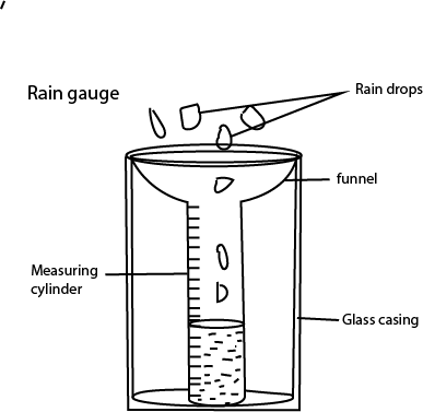
Each day rain water collected into the measuring cylinder is recorded in millimeters and total monthly values obtained.
Types of rainfall
- The types of rainfall based on intensity can be classified as:
Light rain – Rate of rain varies between 0 to 2.5 millimeters
Moderate rain – Rate of rain varies between 2.6 millimeters to 7.6 millimeters
Heavy rain – Rate of rain is beyond 7.6 millimeters
- Types of rainfall based on the origin can be classified as:
Convectional Rainfall
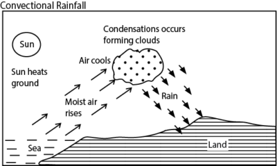
Convection rainfall is a type of rainfall which occurs when the ground surface is heated by the sun’s insolation leading to upward movement of warm moist air. The rising air cools to form strato-cumulous clouds; condensation takes place leading to formation of rainfall accompanied by thunder and lightning.
This type of rainfall occurs throughout the year around the equator and internal parts of the continents, predominantly in the northern hemisphere.
Factors promoting the formation of convectional rainfall in east Africa
- Presence of water bodies e.g. Indian Ocean, L. Victoria, L. Albert that provide moisture in the air
- Latitude; East Africa is astride the equator and thus there is enough solar heat to cause evaporation
- The meeting of trade winds in the low pressure belt due to the (ITCZ) triggers off the upward movement of convectional currents that form clouds
- Dense vegetation provide moisture through transpiration
- Human activities such afforestation and industrialization that provide heat leading to evaporation.
Orographic rainfall
Orographic rainfall is precipitation produced when the saturated air mass comes across a mountain and forced to rise and condense into rainfall. The wind ward side of the mountain with ascending moist air receives much more rainfall while leeward side (rain shadow area) of the mountain with descending dry air receives little or no rainfall. This type of rainfall is common in mountainous areas such as Mt. Kilimanjaro, Mt. Kenya, and Mt. Rwenzori etc.

Factors promoting the formation of Orographic rainfall in east Africa
- Presence of water bodies such Indian Ocean, L. victoria, etc.
- Presence of winds
- Presence of highlands and mountains
Frontal/depression/Cyclonic Rainfall
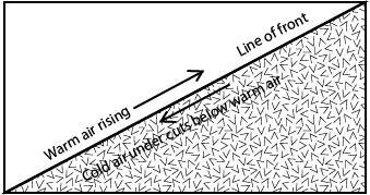
It occurs when two air masses of unlike density, temperature and humidity meet along the fronts of a cyclone. The warm air is light and therefore rises on the top of the cold dry air mass. As the warm air rises, it coos and the moisture present in it condenses to form clouds leading to precipitation.

Cyclonic rainfall is mostly experienced in the temperate latitude. It is associated with hailstones and strong winds which are highly destructive to settlement and crops.
Front
A front is a narrow zone of transition between air masses of contrasting density, temperature and humidity. There are three types of fronts
- Cold front is formed when a cold air mass advances into a region of warm stable air. The cold air is dense and dry; it displaces and causes the warm air to rise.
- Warm front is formed when warm air mass advances into a region of cold stable air. The warm air being light overrides the cold air mass and rises. As the warm air rises, it expands and cools to saturation point forming clouds and rainfall.
- Occluded front is formed cold air mass front and a warm front meets and merges into each other.
Hail/Hailstone
- Hail is a form of precipitation made up of frozen rain droplets which range between 5-50mm in diameter. It consists of balls or irregular lumps of ice, each of which is known as a hailstone.
- Hail forms when a thunderstorm updraft lifts a water droplet above the freezing level in the atmosphere. Frozen water droplets coalesce to form heavy hailstone that fall as precipitations due to their weight.
- Hails injure people, crops, plants, animals and property
Dew refers to water droplets normally formed on plant as a result of condensation.
Causes of condensation
Condensation is a process where water changes from vapor to liquid. It occurs when air is cooled to and beyond its dew point.
Cooling/Condensation occurs under the following conditions
- Adiabatic expansion; when air rises into the upper levels of the atmosphere it expands and cools.
- Contact with a cold surface
- Presence of humidity that forms a liquid when air cools.
- Radiation from the earth during the night. During cloudless clear skies the earth loses most of its heat acquired during the day. Towards the morning, the temperature on earth surface reaches dew point and the warm moist air in contact with it condenses into fog.
- Presence of aerosols (condensation nuclei) water vapour doesn’t condense from perfectly clear or pure air. There must be tiny aerosol in form of volcanic ash, smoke, ice crystal or dust. It is these nuclei that have the capacity to attract water particles onto themselves that water molecules gather to produce water in form of clouds.
Annual rainfall
Mean annual rainfall is the sum of rainfall amounts (ml) of each month for every year recorded for a period of 30-35 years and then divided by the number of years.
Rainfall regime
Rainfall regime refers to the seasonal variation of rainfall peaks following the apparent movement of the sun. The apparent movement of the sun creates a low pressure zone referred to as inter tropical convergence zone (ITCZ). It is this zone which due to low pressure the North-East and South-East trade winds meet/converge, rise and condense to produce rainfall. The ITCZ in East Africa occurs twice a year resulting into two rainfall maximas (seasons) a year i.e. in April and October.
The sun is over the equator twice a year on 21 March and 23rd September these days are called solar equinox. Thus the areas of East Africa astride the equator have two rainy seasons. The sun is over the tropic of cancer once on 21 June and over the Tropic of Capricorn once on 22nd December. Areas in the northern and southern hemispheres have each one rain maxima.
Reasons for variation of mean annual rainfall in East Africa.
- Influence of inter tropical convergence zones (ITCZ): this is a low pressure zone that follows the apparent movement of the sun. It is associated with heavy rainfall. Areas around the equator such as Entebbe, Jinja have higher annual rainfall than distant area such as Kaabong in North-Eastern Uganda.
- Altitude: This is the height of land measured from sea level. Areas at high altitude such as Mt. Kilimanjaro, Mt. Elgon have higher annual rainfall than areas at low altitude such as Mombasa.
- Presence of water bodies: areas adjacent water bodies like Lake Victoria receive more annual rainfall those far from the water bodies
- Vegetation: regions rich in vegetation such as Mabira forest receive higher annual rainfall.
- Prevailing winds: the south-east trade wind that emerge from the south Indian Ocean carry heavy humidity and so result into heavy rainfall around the Victoria basin and Kenya Highlands. For this reason they have higher mean annual rainfall than areas like Kaabong and Turkana which are washed by the dry North-East trade winds from Sahara and Arabian Deserts.
- Latitudinal location: This is the equi-angular location from the equator. Areas that are astride the equator such as Kampala, Entebbe, and Kisumu have higher mean annual rainfall than those further from the equator such as Turkana or Central Tanzania.
- Influence of Ocean current: the warm ocean currents raise the temperature of the winds blowing over them, resulting into a low pressure zone. Air/wind blow from land towards the ocean thus become off-shore. This deprives the coastal areas like Dar es Salaam, Mombasa rain hence the low mean annual rainfall. On contrary, Islands in Indian Ocean such as Zanzibar, Pemba receive heavy rainfall hence high annual mean rainfall.
- Human activities such as bush burning, deforestation and swamp reclamation reduce annual mean rainfall while activities like afforestation; reforestation increases the annual mean rainfall.
Atmospheric pressure
Atmospheric pressure is the force/weight of air exerted per unit over the earth’s surface. This weight of air is the vertical column exerted from the upper limit of the atmosphere to the Earth’s surface which is approximately l.034kg/cm3 over the sea level.
Atmospheric pressure is measured in Pascal/bars by using a mercury barometer. OR an aneroid barometer
A mercury barometer
A mercury barometer consists of a glass tube which is inverted over a bowl of mercury.
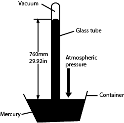
- The glass tube is marked in mm and it’s illustrated above
- Air has weight and therefore exerts pressure on the Earth’s surface; it pushes the surface of mercury and cause mercury to rise up in a glass tube.
- When atmospheric pressure falls, the force on the mercury surface reduced and mercury is forced to flow out of the glass tube leading the height of mercury column to fall.
- The higher the length of mercury column in glass tube, the higher the atmospheric pressure.
- It is expressed in millibars where 750mm of mercury corresponds to 1000 millibars (mbs)
Aneroid barometer

- An aneroid barometer has a corrugated metal box that expands and contracts, depending on the atmospheric pressure around it.
- This is amplified by the lever system to give a reading on the scale that may be calibrated in bars, Pascal or atmospheres
The factors that influence the atmospheric pressure of a place
- Temperature differences: An increase in temperature leads to a fall in pressure & a decrease in temperature leads to rise in pressure. For example equatorial region which have hot temperatures due to the sun’s effect have low pressure. This is because hot air expands leading to reduction of its mass per unit area.
- Altitude: This is the height of land above the sea level. Air pressure is created due to weight of air therefore sea level has highest air pressure. Moving above sea level air pressure decrease because the proportion of lighter gases (like nitrogen) leading to the decrease in air density decreases. For example air pressure at Mombasa (sea Level is greater than at higher altitude like Kampala or Kasese.
- Moisture in Air (Humidity): As humidity increases pressure decreases because water vapor is less dense than dry air at the same temperature; the addition of water vapor decreases the overall density of the air and lowers its pressure.
- Gravitation of Earth: Atmosphere glues around the Earth due to its gravitation. The intensity of gravitational pull decreases as we get away from core of Earth. Another fact is that as Earth rotates round its axis, average distance of Polar Regions and equatorial regions varies from the core of Earth. For example Polar Regions are nearer to core of the Earth as compared to Equatorial regions and hence have higher air pressure.
- Rotation of Earth: Rotation of Earth produces centrifugal force which has more effect in Equatorial region while lesser effect on Polar Regions. Centrifugal force pushes things away from its core. Same is the effect on air pressure which results into lesser pressure in Equatorial regions as compared to that in Polar Regions.
- Latitudinal variation: Along the equator there is much more heat and therefore low pressure, towards the pole temperature decreases & therefore there is high pressure.
- Nature of the Earth’s surface/ land & Sea breeze. During day the land heats up faster than water. Hot temperature over land leads to low pressure. During night the land lose its heat very rapidly while the sea is warmer. This creates hot temperature on the sea hence low pressure.
- Time of day. At noon air pressure decreases due to high temperature while during the evening and night temperature drop leading to an increase in atmospheric pressure.
- Motion or stability of the air. At the same temperature and vapour concentration, an air mass moving on the surface will exert less pressure than an air mass with similar characteristics but which is simply rests on the surface.
- Seasonal changes: atmospheric pressure changes with season. During winter its cold and so pressure rise and summer temperatures are hot and so pressure reduces.
Effect of atmospheric pressure on weather and climate
- Abrupt change of atmospheric pressure result into steep pressure gradient leading to formation of typhoons and hurricanes
- Anticyclone results from gentle change of atmospheric pressure over a wide area. This results into soft winds associated with dry conditions
- Differences in atmospheric pressure results into movement of air from regions of high pressure to regions of low pressure.
- Movement of air results into convergence of air masses of different characteristics that lead to cyclonic rainfall.
- Uniformity of atmospheric pressure over a wide area results into calm conditions favorable for economic activities like farming.
Wind
Wind is the moving air
Direction of wind
Wind direction is generally reported by the direction from which the wind originates. A wind vane is an instrument that shows you the direction of where the wind is coming from. Due to the rotation of the Earth, all winds on the surface of the Earth are deflected to the right in the Northern Hemisphere and to the left in the Southern Hemisphere.
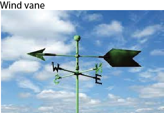
The arrow points in the direction the wind is blowing from.
Wind speed
An anemometer is an instrument that measures wind speed in km/hr and wind pressure in bars.
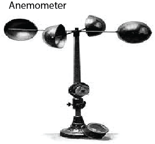
The wind blowing into the cups causes the spindle to rotate and the readings obtained from the counter
Uses of wind
Humans use this wind flow, or motion energy, for many purposes including; generating electricity, sailing, milling grain, pumping water, powering cargo ships (via kites), reducing carbon footprint, wind surfing and land surfing.
An ocean current
An ocean current is the general movement of surface water in the ocean in a fairly defined direction.
Causes of Ocean currents
- Winds blowing over surface of the water creating friction on the surface water.
- Differences in water density where the dense water from poles flows towards the equator and vice versa.
- Rotation of the earth deflects the currents to the right in northern hemispheres and left in southern hemisphere.
- The shape of land masses where islands split the ocean currents into two.
- Ocean currents are divided into warm Ocean currents and cold Ocean currents. Examples of warm Ocean currents include Mozambique currents, North Atlantic drift, Kuro siwo etc.
- Cold ocean currents include Benguela, cool canaries, Californian current etc.
- Warm Ocean currents are characterized by warm temperatures, they flow from low latitudes near the equator to the high latitudes and they flow from areas of low pressure to areas of high pressure and generally flow on the eastern side of continents etc.
- Cold Ocean current are characterized by cold temperatures, they flow from the high latitudes to low latitudes towards the equator, flow from areas of high pressure to areas of low pressure and generally flow on the western side of continents etc.
The influence of ocean currents on the climate of Africa
Africa’s coastline is affected by the following ocean currents. The warm Mozambique/Agulhas ocean current on the Eastern coast of Southern Africa, the Benguela cool current on the west coast of Africa near Namibia and South Africa, the warm Guinea current along the coast of west Africa and the cool canary current on the North western coast of Africa
The warm ocean currents above have influenced climate in Africa in the following ways:
- They increase temperature of water which in tum warms the on-shore winds thereby increasing temperatures of the adjacent land masses e.g. Durban has a temperature of 24.4°C.
- There is high evaporation on the surface water causing increased moisture/humidity in the atmosphere. The onshore winds pick up the moisture, condensation occurs causing cumulo-nimbus clouds and thereby causing heavy to moderate rain fall which occurs along the coastal areas e.g. Durban.
- The moisture carried by the onshore wind leads to the formation of thick cloud cover e.g. port-Elizabeth.
The cold ocean currents I.e. Benguela and cool canaries have influenced climate in the following ways.
- The cold water reduces the temperatures of cold the onshore winds hence temperatures of the adjacent land masses are also reduced e.g. Port Nolloth in Namibia has an average temperature of 120
- The low temperatures of the surface water limit evaporation in the atmosphere and therefore low water vapour/humidity. The onshore winds have limited/low moist causing dry conditions on the adjacent shores e.g. the cold Namibia Desert on the west coast
- Advection and/or foggy conditions also occur along the areas when the onshore winds blow over the cold water e.g. along the coast of Namibia.
- There is an also limited cloud cover/clear sky due to the low humidity in the atmosphere.
Land and sea breezes
Land and sea breezes are local winds which occur in areas where land is lying in close proximity to a water body e.g. around the shores of Lake Victoria and the coastal areas of East Africa.
Land breeze blows from land to sea/lake and occurs during the night while sea breeze blows from the sea to the land and occurs during the day.

Factors/causes of land and sea breezes
- Differences in the specific heat capacities between land and sea; land absorbs and loses heat quickly than sea water.
- Differences in reflecting capacities; seas reflects light more than dark land and takes longer to warm up.
- Differences in mobility; water is mobile which is mobile tends to lose a lot of heat than land which is immobile. Thus land heats up very fast
- Heat transmission; there is higher transmission of heat through water than land. Thus water absorbs large amount of heat compared to the same volume of land.
Land breeze (occurs during the night)
- At night land cools faster than the sea and temperatures are cooler on land than over the sea
- Low pressure is created over the warm sea and high pressure over the cold land.
- Cool air from the land under high pressure blows towards the sea to replace the rising air hence land breeze.
Effects of land breeze
- Cooling over the sea causes fog or mist leading to poor
- Temperature inversion occurs over the sea
- Land breeze/winds to the sea may propel boats and ships making navigation easy.
- Land breeze produces rainfall at night at the sea affecting fishing and navigation.
- Dry condition on land because little or no rainfall is received
- There is also formation of cloud cover over the sea.
Sea breeze (occurs during du day).
During the day land heats faster than the sea. This creates a low pressure zone on land causing air currents from the sea towards land.

Effects of sea breeze.
- Lowering of temperature on land especially in the afternoons which results in poor visibility.
- On shore convectional rainfall is formed which is usually received in afternoons.
- It results into violent thunderstorm.
- It also results into high humidity on land.
- There is also formation of cloud cover over land.
Clouds
Clouds are visible accumulations of tiny water droplets or ice crystals in the Earth’s atmosphere.
On Earth, clouds are formed as a result of saturation of air when it is cooled to its dew point or when it gains sufficient moisture from adjacent sources to raise the dew point to the ambient temperature.
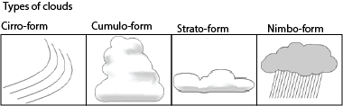
Luke Howard divided clouds into three main categories;
- Cirro-form clouds (latin: Cirro –hair) are whitish and hair-like
They are the high, wispy clouds to first appear in advance of a low-pressure area such as a mid-latitude storm system or a tropical system such as a hurricane
- Cumulo-form clouds are generally detached clouds, they look like fluffy cotton balls.
They show vertical motion or thermal uplift of air taking place in atmosphere. They are usually dense in appearance with sharp outlines. The base of cumulus clouds is generally flat and occurs at the altitude where the moisture in rising air condenses.
- Strato-form clouds are usually broad and fairly wide spread appearing like a blanket
They result from non-convective rising air and tend to occur along and to the north of warm fronts. The edges of strato-form clouds are diffuse.
- Nimbo-form clouds are a special rainy cloud category which combine the three forms Cumulo + Cirro + Stratus.
The vast majority of precipitation occurs from Nimbo-form clouds and these clouds have the greatest vertical height.
Importance clouds
- They are part of rainfall cycle that can produce rains
- Regulate atmospheric temperature by regulating the amount of solar energy that reaches the surface and the amount of the Earth’s energy that is radiated back into space.
- Reduce visibility and can lead to accidents in space
Humidity
Humidity is the amount of water vapor in the air. It is measured by use of a hygrometer.
Hygrometer
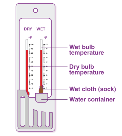
It consists of two ordinary thermometers, the dry bub and wet bulb thermometers
The dry bulb thermometer measures ambient temperature while the wet bulb thermometer measure (a lower) saturation temperature of air. The difference in the readings of the two thermometers is a function of humidity interpreted from the tables
- When the air is 100% saturated, both thermometers show the same reading
- A small difference indicate high humidity while a big difference in temperature reading indicates low humidity or that the air is dry.
Relative humidity is a ratio, expressed in percent, of the amount of atmospheric moisture present relative to the amount that would be present if the air were saturated at a given temperature and pressure.
Absolute humidity is the mass of water in (grams/m3) per unit volume of dry air regardless of its temperature. The higher the amount of water vapor, the higher the absolute humidity.
A body of air at a given temperature and pressure can hold a fixed amount water vapour. When this limit is reached, the air is saturated. This means that the air contains the maximum amount of water vapour at that temperature and cannot take in any more. If saturated air is cooled, some of the moisture changes to liquid or solid state (condensation). The amount of water that saturates a fixed volume of air at constant pressure increases with an increase in temperature. Thus unsaturated air gets saturated when cooled.
The dew point is the temperature the air needs to be cooled to (at constant pressure) in order to achieve a relative humidity (RH) of 100%.
Factors that influence humidity of a place
- Temperature; evaporation and thus humidity increases with temperature.
- Presence of water in form of wet soil and water bodies; places around water bodies experience high humidity due to presence of that evaporates
- Vegetation increase humidity of a place through transpiration
- Altitude; there is more humidity at lower levels compared to higher levels because gravity pulls water molecules towards the ground
- Human activities like industrialization increases humidity by releasing water vapour into atmospheres through heating water and releasing heat.
- Warm ocean current have high temperature that enhance evaporation of ocean water leading to high humidity while cold ocean currents inhibit evaporation causing low humidity in air.
- Wind transfer humid air from one place to another
- Continentality/distance from the sea; area close to water bodies experience higher humidity than those far from water bodies.
Effect of humidity on weather
- Condensation of water vapor in air near ground produce fog or mist. In Uganda fog is usually experienced in Kigezi highlands.
- Condensation of water vapor is responsible for formation of rainfall
- Differences in humidity of places cause wind flow
- High humidity causes greenhouse effect
- High humidity causes cloud formation
Global and Local winds
Global winds
Global winds operate within particular latitude of the globe. They cover larger area than local winds e.g. Trade winds, westerlies and polar eastrlies.
Local winds
A local wind operates within a small location/area, it includes land and sea breezes, Chinook, Katabatic and anabatic winds, monsoon winds and tropical cyclones
Chinook winds/ Föhn winds
This is a warm dry wind found on the leeward side of a mountain. Chinook is an American word meaning snow eater because of the ability to melt snow.
Process of formation of Chinook winds
Warm moist air ascends a highland, condenses and forms rain on the windward side. The descending wind /Chinook compress and warm up.
Effects of Chinook wind
- Melts ice/snow that may lead to flooding.
- Since they are warm and dry, Chinook from Mt. Rwenzori have caused aridity in Kasese, Fort Portal, Ankole and Masaka. Chinook from Ethiopian highlands have caused aridity in Karamoja and Turkana land of Northern Kenya.
- They boost tourism in mountainous regions like Switzerland by limiting snow coverage.
- The Chinook winds stabilize the weather by creating an increase in atmospheric temperature
Katabatic and Anabatic winds
They are winds more pronounced in mountainous regions like Switzerland, Rwanda, Kigezi highlands etc.
Anabatic Winds /valley breezes are upslope winds that occur during the day. During the day slopes heat up faster than the valleys; the hot slope warm the surrounding air which expands and replaced by the denser air from the valley.
Effect of anabatic winds
- Anabatic winds transport cold temperature to upper slope during the day.
- Anabatic winds lead to formation of mist and fog in the upper slopes of Mt. Kilimanjaro and Rwenzori
- Anabatic winds lead to formation of low clouds in highland areas of Kilimanjaro, Rwenzori
- Anabatic clouds promote growth of mountainous vegetation through formation of rainfall.
Katabatic winds/mountain breezes are downslope winds due to gravity at night. At night slopes cool faster than the valleys; the cold slopes cool the surrounding air; the air becomes denser causing it to descend into the valley
Effects of anabatic winds
- Katabatic winds lead to formation of fog or mist due to radiation cooing in valleys within Alps valleys of Switzerland and Kigezi highlands.
- Katabatic winds transport cold conditions in the valleys at night. That is why it is very cold in Kigezi valley and Ntungamo at night.
- Katabatic winds result into temperature inversion where the temperature in the valley is colder than that above e.g. in Kapchora and Kabale.
Monsoon winds
Monsoons are seasonal winds which move in the Northern hemisphere especially, India, Bangladesh, Japan and along the East African coast accompanied by corresponding changes in precipitation.
Formation of monsoon winds
During December-January, the Northern Hemisphere experiences winter. These low temperatures lead to high pressure zone within the Asiatic land masses. Meanwhile, the insolation of the sun in the southern hemisphere causes low pressure zone. This difference in pressure causes winds to from the Northern to Southern Hemispheres. Alternatively, a low pressure zone in created in the Northern Hemisphere in summer (June-August) leading to the flow of winds from the Southern Hemisphere to the Northern Hemisphere.
Effects of Monsoon winds
- Monsoon winds are associated with heavy and disastrous rainfall which cause flooding along the coast of India. In East Africa they bring some rains on the coast around Mombasa, Malindi, Kilwa and Dar es Salaam.
- They were historically used by sailors to propel boats and ships for the Arabs
- They cause hot temperatures on the East African coast.
- They cause humid conditions on the East African coast
Tropical cyclone/Depression
A Cyclone is a low pressure wind system that moves at an averagely high speed of 250km/hr, with a diameter between 80 and 400kms
A tropical cyclone is an intense violent tropical storm that occurs in the tropics particularly along the I.T.C.Z (Inter-Tropical Convergence Zone).
- They occur in tropical oceans, mainly on the Eastern side of the continents between 5° and 20° North and South of the Equator.
- They occur between July and October in the Northern Hemisphere and January to April in the Southern Hemisphere.
- Tropical cyclones have steep pressure gradients with violent winds circulating in wards Anti clock wise direction in the Northern Hemisphere and in a clock -wise direction in the southern Hemisphere.
- Thus Tropical cyclones usually develop/originate from oceans /seas and move towards land masses. They originate on the western sides of oceans and move towards the Eastern sides of continents.
Tropical cyclones are known by different Names depending on where they occur
- Hurricanes in Mexico, Caribean. Seas and North Atlantic Ocean.
- Typhoons China, Japan, Philippines and Pacific Ocean.
- Willy- willies on the Eastern Australian coast.
- Tornadoes in USA
- Cyclones in the Indian ocean.·.
- Tropical cyclones occur in all tropical oceans/seas except southern Atlantic
Causes of Tropical cyclones
- Cyclones originate from a local heat source that is in the ocean /sea – surface.
- A wave disturbance is caused /occurs due to differences in the local temperatures and hence pressure differences over the ocean surface.
- A wind begins to cycle around the area of low pressure called the ”EYE”, which is a zone of calm, dear skies and descending dry winds.
- This builds up momentum into very strong and violent wind through the process of Cyclo -thesis (convective movement of violet wind) developing a towering Cumulonimbus clouds
- This is because there is a constant supply of moisture from the warm water body/ ocean (the local source of heating)
- It develops a steep barometric gradient in the “LOWS” (low latitudinal areas) giving rise to high speed winds (gusty winds)while the “EYE”‘ constantly develops calm weather conditions.
- Tropical cyclones therefore develop on the ocean surfaces due to maximum instability in the atmosphere
- Tropical cyclonic movements are in the direction of the wind.
Characteristics of tropical cyclones
- They originate from within the tropical latitude usually between 5° and 200 North and south of Equator
- They cover a diameter of between 80-400 km
- They occur between July and October in the Northern hemisphere and January to April in the Southern Hemisphere.
- They usually originate from oceans and move towards land masses. They originate from the western sides of oceans and move towards the Eastern sides of continents.
- Tropical cyclones are associated with gusty winds. Winds blow at high speed ranging from 150km/h to 250km/hr.
- Cyclones result into thunderous and heavy rainfall full of lightening. At many times trees and animals are stroked to death by the lightening
- A combination of dense clouds, torrential rains and very fast winds reduce visibility to a few metres.
- Cyclones are associated with high temperatures of over 270 These warm up the air resulting into heavy convective instability and formation of dense cumulonimbus clouds.
- Sudden appearance of calm, clear, and dry conditions with the advance of the eye and then violent conditions:
- The circulation of winds (air) is anti- clockwise direction in the Northern hemisphere and clock-wise in the southern hemisphere
- Direction of movement of cyclones is basically determined by wind direction.
Weather conditions associated with tropical cyclones.
The weather conditions associated with tropical cyclones are winds, pressure, humidity, clouds and rain
- These weather conditions vary with vortices. Those in the advance vortex may be similar to those in rear vortex. But those in the eye of the storm, they are different
- Before the arrival of the storm; they are characterized by; high pressure, calm and still air, hot temperatures.
Weather conditions in the advance vortex
- There is decreasing atmospheric pressure
- Increasing wind speed and winds tend be violent i.e. surge upwards at high speed of an average of 150- 200km /hour
- Developments of dense clouds cover due to up surging of humid winds that they condense.
- Heavy rainfall, with lightning and thunder storms which may exceed 500mm in only 24 hours
- Reduced visibility due to low and dense cloud cover as well as stormy conditions
- Temperatures tend to be hot, a counting for the great evaporation and consequent humidity
Weather conditions in the eye or the storm
- There are calm winds /light winds/stationary or still winds.
- Temperatures are generally hot
- There are bright and dry conditions
- The skies are clear with hardly any cloud
Weather conditions in the rear vortex
- These is low, but rising atmospheric pressure
- There are strong winds with high speed between 120-200.km/hr
- Winds are also marked by vertical instabilities i.e. rising air currents.
- It tends to be cloudy i.e. there are dense clouds
- There is high humidity
- There is heavy rainfall, accompanied by thunder storms

Effects of tropical cyclones
Cyclones affect both weather and human activities.
Effects of tropical cyclone effects on weather are;
- -Cyclones are associated with gusty winds. Winds blow at high speed ranging from 116km/hr to 250km/hr. Tornadoes can reach speeds of500km/hr; such winds are very destructive.
- Cyclones result into thunderous and heavy rainfall full of lightening. At times trees and animals are stroked to death by the lightening
- A combination of dense clouds, torrential rains and very fast winds reduce visibility to a few metres.
- Cyclones are associated with high temperatures of over 27° C. These warm up the air resulting into heavy convective instability and formation of dense cumulonimbus clouds.
- Sudden appearance of calm, clear, and dry conditions with the advance of the eye and then violent conditions
- They are characterized by high humidity and temperatures.
Cyclones affect human activities and coastal areas in tile following ways;
- -In India & New Orleans & Bangladesh Violent winds blow up settlements, ships and most of the infrastructure. This leads to loss of shelter, total power blackout due to destruction of electricity lines and destruction of the transport infrastructure.
- Violent winds lead to loss of livestock, crops and humans are killed by flying debris or suffocated to death by the gusty winds. Breathing is very hard under such winds.
- Cyclones result into flooding of coastal islands and towns. In U.SA, New Orleans and Florida are usually flooded. In India coastal towns flood and slums are hit most.
- Cyclones are normally followed by an outbreak of water borne diseases liked diarrhea, cholera etc. this is a result of floods. Such diseases are common in India, Bangladesh and New Orleans in USA where the Katarina cyclone caused havoc in 2010
- Cyclones lead to food shortages which may result into famine. This is a result of the destruction of crops, animals and the entire social and economic infrastructure.
- Disturbance of shipping and aviation travel industry because of the gusty winds, torrential rains and poor visibility.
- Land degradation due to massive erosion and mass wasting resulting from torrential rains especially near the coast.
- Salination of coastal lands because of the periodic sea incursions thus affecting crop cultivation.
- They destroy vegetation by uprooting trees and braking branches thus destroying leisure parks, along beaches
Air masses
An air mass is a large body of air with uniform horizontal temperature and humidity conditions.
Air masses form when stationary air settles over a large uniform surface area for long enabling it to acquire uniform conditions.
There are two categories of air masses namely Arctic polar and tropical air masses. They are classified according to their origins. These are also classified into four types namely maritime polar, continental polar, tropical continental and tropical maritime.
Polar maritime air mass originates from the water regions of the poles. It starts over the clod ocean water of North Pacific Ocean, North Atlantic Ocean and Arctic Ocean. It brings heavy winter rains; snow in mountain and persistent coastal fog in summer in USA.
Continental polar air mass is cold and dry. It begins from continental interiors of Northern Tundra of North America, Greenland and Asia. During winter, the air mass is very cold because its source regions are snow capped with low temperatures. During summer when the source regions are warm, the continental polar takes on mid conditions.
Tropical maritime air mass is warm and humid from oceanic regions within the tropics where temperatures are generally high.
Continental tropical air mass is hot and dry because it originates from sub-tropical deserts of continents along latitudes 350 to 400 of equator. It produces cloudless skies and poor visibility due to fog. As it travels over the Mediterranean Sea, it coos, picks some moisture which it drops as isolated showers and thunderstorms north of the Mediterranean coast.
Characteristics of Air masses
- Air masses originating from the poles tend to be cold while those originating from the tropics such as continental tropical air masses tend to be warm.
- Air masses have uniform humidity throughout the year.
- Air masses have a definite direction of movement from a region of high to that of low pressure.
- Air masses have a uniform temperature over a considerable area because they remain in their area of origin for a considerable period of time.
Formation of air mass
Air masses form because
- Differences in temperature at the source and surrounding regions leads to difference in pressure that causes flow of air. Air moves from a region of high pressure to a region of low pressure.
- Effect of earth rotation creates a drag force called corriolis force. Any free body on the Earth’s surface is deflected to its left in the southern hemisphere and to its right in the Northern Hemisphere
- Nature of the earth’s surface also determines formation of air masses. Air masses develop over an area which is extensive and uniform in build and shape e.g. desert surfaces such as Sahara Desert, and ocean surfaces.
- The path taken by air such as land and water surface determines the final characteristics of the air. For instance over water air may pick moisture.
Influence of atmospheric instability on weather conditions of a place
- Rainfall results from condensation of upward moving air
- Hot air ascend and is replaced by cool air leading to cooing of a place
- Formation of mist and fog results from cooling of air in the lower levels of the atmosphere.
- Clouds form as a result of cooling of rising air in upper atmosphere.
- Instability increases humidity in atmosphere
- Atmospheric instability results into wind
Terrestrial radiation (Thermal Radiation)
- This is the energy transmitted/transferred from the earth’s surface to the atmosphere.
- Radioactive decay of isotopes at the earth’s surface contributes to the terrestrial radiation.
- Terrestrial radiation is transferred in the form of long waves (electromagnetic radiation) and occurs all the time both during day and night.
- The amount of terrestrial radiation varies with the nature of the surface area and its size, e.g. water surfaces emit less radiation than land surfaces. Mountain tops also emit less than the low lands.
- The air, water vapor and clouds take up a great deal of this energy emitted by the earth thus resulting in the rising of temperature in the atmosphere which is measured and recorded at a weather stations.,
- Terrestrial radiation therefore results into a rise in the temperature of the atmosphere.
Solar radiation

- Solar radiation is the energy transmitted from the sun to the earth through the atmosphere.
- It passes in the atmosphere in form of a beam of short wave rays (solar short wave radiation).
- Solar radiation is received in a place during the day in form of light and converted into heat at the earth’s surface.
- The amount of solar radiation received in a place also varies from time to time. The air, clouds and the ozone absorb some of this energy while dust particles and clouds themselves reflect and scatter the energy into space.
- The earth therefore absorbs only a fraction of the energy emitted by the sun. Albedo is used to express the ability of a surface to reflect insolation
- Is in form of visible light rays, UV rays, X-rays and gamma rays.
Conditions that influence the in-coming solar radiation in an area
Latitude
The angular distance of a place from the equator partially determines the distance from the sun to the earth’s surface. This further determines the angle of incidence at which the sun’s rays fall upon the earth’s surface.
Thus, there is always maximum insolation in low latitudes because the sun’s rays strike the earth’s surface at right angles and have a short distance to travel through the atmosphere. There is intensive heating since there is a smaller surface area per ray. The sun’s rays are however less intensive towards the mid-latitudes and Polar Regions because of the long desistance they travel through the atmosphere and the oblique angle at which they strike the earth’s surface.
Rotation of the earth
The rotation of the earth on its axis causes changes in solar radiation received in a place. Within the tropics the sun is overhead and higher amounts of solar radiation are received. Absence of the overhead sun at the poles, artic and sub-arctic regions reduces radiation rates.
Revolution of the earth:
This cause seasonal variation in the amount of radiation received in the different places of the global earth. More solar radiation in experienced during summer season compared to winter season.
Cloud cover:
Clouds in the atmosphere do absorb, reflect and refract radiation and this reduces the amount of solar radiation reaching the earth’s surface. This implies that areas with a dense cloud cover receive less solar radiation as compared to areas with clear skies.
Aspect:
Areas in the direct path of the sun’s rays and especially in the mid and high latitude areas receive more solar radiation as compared to those areas sheltered from the sun’s rays e.g. in the mid-latitudes of the Northern hemisphere; the South facing slopes receive more solar radiation than North facing slopes. This is because the South facing slopes in northern hemispheres are in the direct path of the sun rays.
Humidity:
The amount of water vapor in the atmosphere may absorb or reflect solar radiation. It prevents some percentage of the solar radiation from reaching the earth’s surface. Areas with less humidity e.g. arid and semi-arid regions receive more solar radiation on their surface because direct heat from the sun is received.
Impurities in the atmosphere:
Impurities in atmosphere such as smoke and dust particles tend to absorb part of the solar radiation reaching the earth’s surface. This means that areas with much atmospheric impurities will receive less solar radiation as compared to clear atmospheric conditions.
Amount of the greenhouse gases (GHE)
The increase in the amount of Greenhouse gases such as CFCs in the atmosphere may affect the ozone layer. The depletion of ozone layer will trigger the occurrence of global warming- a condition that increases the amount of solar radiation. On the other hand, areas with less/ limited atmospheric Greenhouse gases have the ozone layer still intact and therefore experience less solar radiation reaching the earth’s surface.
The length of the day and night
Due to rotation of the earth around the sun; during summer the day hours are longer than the hours of the night and thus more insolation is achieved than in winter where night hours are longer.
Nature of the receiving surface/Albendo
Dark surfaces receive more insolation than white surface
Measurement of sunshine
Sunshine refers to the rays of sunlight reaching the earth’s surface.
Sunshine is measured using either Campbell-Stokes sunshine recorders or modern sunshine sensors. A pyrometer is used for measuring global radiation
Campbell-Stokes sunshine recorders a glass sphere concentrates sunlight onto a card and the amount of scorching on the card records the amount of sunlight that had fallen on it.
The level of sunshine is measured by the duration of sunshine; the unit of measurement is the minute (or hour).
Physical geography Chapter 12: Climatology (weather) in East Africa – Digital Teachers Uganda
[url=http://www.go377eom69n06ipgvlf1v5794kt78j02s.org/]uofdebmfrt[/url]
ofdebmfrt http://www.go377eom69n06ipgvlf1v5794kt78j02s.org/
aofdebmfrt
Postmodern Creative Pink Princess Room Tassel Table Lamp
ChargingSolution
cheap kimikick ru shoes New Balance 57 40 low-top sneakers MEN
email.njp.ac.th
Architectural LED flood lights
rep kimi kicks New Balance logo-patch panelled suede sneakers MEN
Modern Fashion Candy Iridescent Macaron Colorful Desk Lamp
Mushroom Home Decor Villa Nordic Pink Metal Table Lamps
reps kimikick ru New Balance BB550 low-top leather sneakers MEN
No Mercury Led Tubes
AC plugs
where to buy kimikick ru review New Balance x Joe Freshgoods 990v6 “Paris Red” sneakers MEN
Retro Unique Glass Flower Living Nightstand Desk Lamp
Batteries
cheap good kicks ru New Balance 580 leather sneakers MEN
Led Bar Bedroom Living Room Minimalist Glass Table Lamps
Bathrooms Sets
Cheap Authentic Sneakers Athletic Footwear for Women FF Jordan Fly FV5304-010 Online Discounts Under $50 Local Stores
New Minimalist Simple Shade White Lampshades Table Lamp
How to Find Discounts on Shoes kids' FF Jordan Jumpman Pro FV5296-013 Limited Time Offer Under $30 Free Returns
Bathroom Supplies
USB Rechargeable Touch Makeup Mirror Love Table Lamp
Best Places to Buy Sneakers preschool toddler FF Jordan Jumpman Pro FV5296-100 Free Shipping Below $100 Nearby Shoe Stores
Bathroom Accessory Sets Clearance
Hot Selling Decorative Rechargeable LED Golden Table Lamp
Japanese Living Room Bedroom Hotel LED Paper Table Lamp
Bathroom Sets For Cheap
dinhvisg.com
Original Cheap Shoes Fall Sneakers for Men FF Jordan Fly FV5297-436 Affordable Prices under $90 free shipping
Cheap Original Clothing Best FF Jordan Jumpman Pro FV5296-010 Clearance Sale Under $40 Fast Shipping
Bathrooms
Reading Decorative Lamp Nordic Designer Creative Table Lamp
New Cute Eye Care Protection Led Rechargeable Desk Lamps
h2s gas detector
Modern Touch Lamp Cordless Plastic Wine Bottle Table Lamp
Popular Creative Gift Cinnamoroll Anime Tricolor Desk Lamp
http://www.czarna4.pl
lng gas detector
benzene gas detector
cheap kimi kick shoes review Jordan x CLOT Air Jordan 14 Retro Low “Terra Blush” sneakers MEN
High Quantity Cute Mushroom Bedside Dimming Desk Lamp
where to buy kimi kick shoes sale Jordan Air Jordan 1 KO “Greyscale” sneakers MEN
where to buy kim kick Jordan Air Jordan 5 Retro “Trophy Room” sneakers MEN
Home Decor Touch Dimming DC Study Smart Desk Lamp
gas leak detector with solenoid valve
interconnected carbon monoxide detector
reps kids kimikick yeezy Jordan Air Jordan 1 Retro High OG NRG “Rust Pink” sneakers MEN
rep friday Jordan Air Jordan 13 Retro “Reverse He Got Game” sneakers MEN
Outdoor Waterproof One-piece Cartoon Dinosaur Kids Rain Coat
Lead Screw Linear Stage
Cheap online deals ugg winter boots uk sale Converse, Women's Chuck Taylor All Star Cruise Platform Sneaker – Herby Egret White 'online store' under $150 same day dispatch
Funky Waterproof Cartoon Animal Children's Clothing Raincoat
Linear Bearing Rail
Polar Fleece Warm Cold Resistance Cycling Face Mask
Custom Heavy Duty Rain Coat PVC Waterproof Rain Poncho
Cheapest online deals boys ugg boots Birkenstock, Women's Boston Pro Slip On Clog – Black 'deal of the day' under $180 quick and easy checkout
Wholesale Waterproof Thickened Waterproof Oily Shower Cap
Get the best price ugg slippers sale Birkenstock, Women's Arizona EVA Narrow Sandal – Papaya 'special deals' under $50 exclusive sales
Stepper Motor Actuator
Multi-Axis Platform
Where to get cheap real uggs Birkenstock, Men's Birki Air 2.0 Casual Clog – Black 'price drop' under $200 limited time discounts
Best way to buy womens ugg slippers Birkenstock, Women's Highwood Chelsea Boot – Black 'instant savings' under $190 online storewide sale
Air Bearing Rotary Table
configurator.irizar.com
Pla+ Filament 1.75 Mm
Online discounts for navy uggs UGG, Girls' Classic II Sheepskin Boot – Grey 'latest items' under $110 special discounts
Abs 3d Filament
3mm Pla Filament
High Quantity Cute Mushroom Bedside Dimming Desk Lamp
Cute Mini Portable 360 Rotation Flexible Reading Bee Desk Lamp
Pla Plus
Unique Creativity Cute Morden Bedside LED Paper Desk lamp
Abs 3d Filament
arkbaria.xsrv.jp
Where to find authentic classic ugg boots UGG, Women's Mini Bailey Bow II Boot – Black 'exclusive shopping' under $140 online store
Buy authentic items cheap ugg kenly UGG, Women's Bailey Button II Sheepskin Boot – Black 'super shopping' under $170 best deals online
Best discounts on ugg boots usa UGG, Women's Classic Short II Sheepskin Boot – Chestnut 'great value deals' under $130 secure payment
Home Decor Touch Dimming DC Study Smart Desk Lamp
Buy cheap online deals ugg knightsbridge UGG, Women's CLASSIC SHORT II Sheepskin Boot – Black 'clearance deals' under $120 new in store
Popular Creative Gift Cinnamoroll Anime Tricolor Desk Lamp
Affordable Gucci Replica Louis Vuitton LOUIS VUITTON Damier Ebene Triana Best deals Best deal Tax-free shopping
Real Stone Paint Rotating Display Stand
rpmg.nl
Vertical Display Stand
Psc Tool
Replica luxury bags Affordable handbags CHANEL Calfskin Nude 2.55 Medals Reissue 226 Flap Navy Cheap replica bags Affordable luxury Guaranteed authenticity
Psc Official
Affordable Gucci Replica Louis Vuitton SAINT LAURENT Raffia Canvas Monogram Lou Camera Bag Black Best deals Best deal Tax-free shopping
Cheap Louis Vuitton Men's BALENCIAGA Extra Supple Calfskin Crocodile Embossed Le Cagole Mini Purse With Chain Acid Green For sale Under $300 Free shipping
Psc Boring Bar Holder
Machine Cutting
Sandvik Tool Holders
Aluminum Gusset Vertical Display Stand
Bathroom Water Pipe Display Stand
Ceramic Display Stand
Discounted Chanel Women's HERMES Chevre Mysore Mini Kelly Sellier 20 Bleu Brume Low price Under $200 Worldwide delivery
Buy quality for cheap Excellent performance Coperni funnel-neck cartoon-print T-shirt Men Smart buy under $180 local stores
HD 3-hexyne-2,5-diol
Bag Palletizing Robot
Pallet Stacking Robots
PABS Diethylaminopropyne Formate
EHS Sodium Isethionate
Best deals for shopping Ultimate luxury Coperni plunging U-neck tank top Men Today's hottest deal under $200 same day delivery
Cement Bag Stacking Machine
Shop authentic goods Minimalist Coperni high-neck mesh T-shirt Men Special discount under $50 in stock
Automatic Floor Level Palletizing Machine
Online shopping for cheap Eco-friendly materials Coperni embroidered-logo short-sleeve T-shirt Men Secure payment under $190 buy online
dclimolinks.com
Shop online for deals Dynamic design Coperni snakeskin-print top Men Buy now and save under $170 fast delivery
Low Position Palletizer
PAP Propargyl Alcohol Propoxylate
HBOPS-Na Butynediol Sulfopropyl Ether Sodium
Affordable crossbody CHANEL Caviar Quilted Medium Boy Flap Fuchsia best price Under $120 near me
Top-rated leather LOUIS VUITTON Monogram Nano Speedy hot sale Under $110 top reviews
Carbon Steel Ball Valve
Where to buy tote VALENTINO GARAVANI PVC Mini Candystud Top Handle Bag Rubin promo code under $90 high quality
Self-priming Electric Water Pump
http://www.fpmontserratroig.cat
Double Tube Water Pump
Top Entry Ball Valve
Premium Self-Priming Peripheral Pump
Low Temperature Ball Valves
Affordable Luxury backpack CHANEL Goatskin Quilted Chic Pearls Flap Black review affordable trendy
Stainless Steel QB style Pump
Cast Steel Ball Valve
How to buy clutch LOUIS VUITTON Empreinte Monogram Giant Onthego PM Black Beige for sale under $100 multi-functional
Circle Type Pickling Line
Premium Peripheral Pump
Perforated Expanded Metal
cheap kimi kick ru shoes Jordan Air Jordan 1 Low “White Black” sneakers MEN
reps kimi kick coupon code Jordan Air Jordan 1 “Game Royal” sneakers MEN
Water Pump Accessories
rep kimi kick shoes Jordan Air Jordan 6 Retro “Carmine 2021” sneakers MEN
Centrifugal Pump
Liensinine
cheap Kimikick Shoes Website Jordan Air Jordan 1 Retro High OG “Shadow” sneakers MEN
High Temperature Oil Pump
12-dion
JET Water Pump
Multistage Centrifugal Pump
where to buy kimi kick ru review reddit Jordan Air Jordan 6 Retro “UNC” sneakers MEN
Expanded Metal Gauge Thickness
radioklub.blansko.net
Stainless Steel Perforated Mesh
Hot Water Recirculating Pump
Swiss Rolex Day Date 40 Platinum Ice Blue Dial Stainless Steel Case And Bracelet
http://www.robutex.pl
Rolex Datejust Swiss Mechanism-srl111
Standard Bucket Gp
Dozer Segment Group
Manual Water Pump
12v Water Pump
Carrier Roller Excavator
Portable Water Pump
Excavator Track Roller
Inline Water Pump
Rolex DayDate Stainless Steel Ribbed Bezel Silver Dial 41976
Rolex Yacht Master Black Dial Silver Case Brown Leather Bracelet 1453859
Front Idler Group
Rolex Day-Date White Dial Gold Bracelet 622546
Multi-Surface Pet Lint Roller Fur Remover Dog Hair Removal
Apartment Gardening Kit
Indoor Plant Growing Kit
Get discounts for black ugg boots Sorel, Botte imperméable LENNOX LACE STKD, femmes 'popular choices' under $120 seasonal shopping deals
3 In 1 Countertop Dual Ice Crusher Dispenser and Cube Maker Machine
Best online buys uggs australia Sorel, Bottes imperméables OUT 'N ABOUT III CONQUEST, fem 'latest styles' under $90 best shopping offers
Buy cheap and authentic ugg slippers women Sorel, Botte imperméable OUT 'N ABOUT III CONQUEST, noir, femmes 'new arrivals sale' under $140 exclusive seasonal deals
Color Changing WIFI Voice Control Smart Light Bulbs
Smart Light No Wifi Offline Voice Control Lamp
Shop online for deals mens uggs Sorel, Botte imp. HI-LINE HEEL CHELSEA, femmes 'top picks online' under $170 fast delivery deals
Color Changing Offline Voice Control Smart Bulbs
Buy cheap goods online ugg noira Sorel, Botte imperméable LENNOX LACE STKD, havane, femmes 'save more' under $130 only at our store
Hydroponic Starter Kit
http://www.haedang.vn
Indoor Plant Lights Decorative
Battery Operated Plant Light
affordable gucci cheap perfume CELIN* BELT MICRO
cheap is it cheaper to buy louis vuitton in paris Fendi Belts 2210XA0068
Long Lasting Naturally Strawberry Pro Handle Eyelash Curler
25kva Diesel Generator Price
100kw Diesel Set
Microfiber Hair Drying with Bow-Knot Shower Hat Hair Turban
Ultra Absorbent Cap Bowknot Soft Microfiber Hair Drying Towels
Hot Selling Manufacturing Microfiber Shower Hair-drying Cap
Water Cooled Diesel Generator
400kw Generator
FYD Stainless Steel Folding Brushes Eyelash Lash Separator
Water Cooled Diesel Generator
http://www.robutex.pl
affordable is louis vuitton cheaper in france Fendi Belts 2301XA0155
cheap gucci cheap slides CELIN* BELT MICRO
rep gucci cheap items CELIN* 16 IN SATINATED CALFSKIN-23*19*10.5cm
Spiral Exhaust Flexible Pipe
cheap gucci dress shoes cheap HERMES LINDY MINI HANDMADE
affordable gucci clothes for cheap HERMES KELLY 25CM ALL HANDMADE TOGO LEATHER
201 Coil
stainless steel
Roof Endura Bracket
Shingle Shovel
Roof Harness Mount
affordable gucci earrings cheap HERMES KELLY MINI II ALL HANDMADE
Stainless Steel Coil Strip
cheap gucci cheap wallet HERMES KELLY 25CM ALL HANDMADE TOGO LEATHER
Roof Adjusta Dock
affordable gucci cheap slides HERMES LINDY MINI HANDMADE
Roof Bracket Dock
Stainless Steel Belt
kerteszkedes.hu
Thanks for being a beacon of knowledge. Industrial & Scientific
Your content never fails to inspire me. Tech News
Access detailed cutoff data with the MBBS Cutoff Of Government Medical Colleges in Tamil Nadu.
Discover affordable pathways to medical careers with MBBS Fees Structure in Jharkhand.
Immerse yourself in thrilling gameplay with Raja Luck Game.
cheap cheap chanel brooch LV Shoes 19SH0038
FLANGE GASKETS
PTFE PRODUCTS
affordable cheap chanel belt LV Shoes 19SH0041
Outdoor Display Advertising
PTFE GASKETS
10 Inch Tablet For Kids
Wireless Photo Frame
7 Inch Android Tablet Pc
Chrismas Gifts
affordable cheap chanel bag LV Shoes 1911SH0003
affordable cheap chanel chance perfume LV Shoes 1910SH0158
http://www.retrolike.net
RUBBER GASKETS AND SEALS
RUBBE SHEET
cheap cheap chanel bags outlet LV Shoes 19SH0043