
Physical geography Chapter 9: Costal geomorphology in East Africa

A coast is part of land bordering the sea or any other extensive tract of water like ocean. The nature of the coast is influenced by wave action, sea level changes and occurrence of coral rocks.
A wave is an oscillation or ripples on water caused by wind, earthquakes, volcanic activity like eruption and/or moving objects on water like ships, boats, fish, animals and so on.
There are two types of waves; constructive waves carry out deposition more than erosion while destructive waves cause more erosion than deposition.
Constructive and destructive waves
Constructive waves are those which result into depositional land form/features such as beaches, bars, mudflats, tombolos, etc. i.e. the waves carry out more deposition than erosion. They have powerful forward movements which push materials up to the coast and weak backwash that cannot pick deposited materials from the coast back to the sea.
The movements of sediments/eroded materials up to the coast at an oblique angle are called longshore drift while movement of water up to the coast at angle is called longshore current. That is waves approach the coast at an angle. Swash carries sediment up the beach at an angle. Backwash carries sediment down the beach with gravity – at right angles to the beach.

Depositional landforms formed by longshore drift include
Beach
Beach is a gently sloping strip of land along the coastline covered products of weathering and erosion such as sand, pebbles, rock and seashell fragments.
The different types of beaches include
Barrier beach is a narrow and elongated ridge of sand deposits approximately parallel to the shoreline separated from it by a lagoon. It is formed on gently sloping Coastlines by longshore drift waves. Materials are deposited under water as off shore sand bars appear above high tide, wave action gradually moves the deposited material to the mainland as barrier beaches.

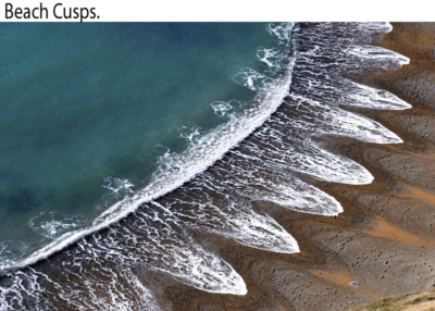
Beach Cusps. Series of small horn-shaped projections separated by shallow indentations that Point Sea wards. Formed by eddies of powerful swash that scours coarser materials in the depression.
A Bayhead beach is a type of beach that is crescent shaped and has developed at the head or back of a bay between two headlands by constructive waves e.g. Lido beach at Entebbe

Beach rock is a friable to well-cemented sedimentary rock that consists of a variable mixture of gravel, sand and silt-sized sediment that is cemented with carbonate minerals and has formed along a shoreline e.g. found at Lutembe beach along L. Victoria

Beach Berms is ridge like features formed by larger material that accumulates at furthest limit of Swash action. Develop on beaches when Swash is stronger than back wash e.g. Lutembe Beach, Lido etc.

Beach Bars
Beach Bars are ridges of sand, Mud, gravel and shingle deposited off shore parallel to the coast.

A lagoon is a lake formed by wave deposition between the sea and shoreline example Lake Nabugabo along the shores of Lake Victoria.
Types of Bars include:
- Off Shore Bars are submerged or partly exposed ridge of sand or coarse sediment that is built by waves offshore from a beach separated from the coast by a lagoon. They are formed by waves breaking some distance offshore where the continental shelf is shallow leading to formation of a submarine bar that is slowly built upwards through continued deposition of material.
- Fore shore Sand Bar is a bar formed by constant accumulation of sand causing offshore bars to rise above the water surface. ,
- Bay Bar is a bar which extends across a bay forms when a spit continues to grow lengthwise from one headland towards another. Link the two headlands enclosing a lagoon e.g. at Nabugabo bay.
- Barrier Island is a bar which gradually moves inland by wave attack and encloses the area of shallow water and have no connection to the mainland.
Spit
A spit is a long narrow ridge of sand, shingle or pebbles in a linear form joined to the land at one end with the other end projecting into the sea or across the estuary.
It grows out from the coastline due to the effect of the long shore drift, often at a location where the line of the coast changes direction, usually at the mouth of an estuary or delta e.g. Kaiso spit and Tonya spit on L Albert.
Types of Spits include:
Hooked Spit is a long narrow ridge of sand, shingle or pebbles joined to the land on one side with hooked end projecting into the sea or estuary. Formed by waves moving obliquely to the shore tending to swing around the end of the spit or waves approaching the shore from several directions force the open part of the spit to bend or curve. The deep water off the spit allows wave refraction to curve hence forming a hooked spit e.g. at Kibanga.

Cuspate Spit applies to two spit converging offshore. It is also a re-curving of a simple spit until it becomes attached to the shore at both ends.

Cuspate foreland is a triangular shaped deposit of sand, shingle projecting sea wards formed by convergence to one apex of two separate curved spits broadly at right angles or by two sets of constructive waves, the enclosed water is filled with deposits then colonized by vegetation leading to a cuspate foreland, e.g at Tonya point.
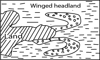
Winged headlands: These are spits attached at both sides of the headland. They develop when spits develop at both sides of the headland. This occurs when waves / longshore drift reach the headland from opposite directions.
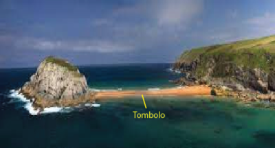
Tombolo is a ridge/ bar of sand or shingle joining an island to the mainland or joining an island to digitalteachers.co.ug an island. When the longshore drift operates between an island and the mainland, sediments may gradually be laid down in that in that zone. Deposition may start on one end of the mainland linking the two up. E.g. Bukakata-Lambu islands.
Mudflats: Platforms of mud, silt and other forms of alluvium along gentle is especially in bays & estuaries. They develop when rivers& waves deposit material along gentle coasts especially in bays and estuaries between high and low tides e.g. near Tanga, mouth of R. Rufigi.

Other factors that influence depositional features in East Africa
- Wind direction which should be such that materials are carried and deposited on the coast.
- Availability of weathered and eroded materials that are transported by constructive waves and deposited at the coast to form various landforms e.g. beaches.
- Presence of a relative shallow continental shelf to form the base upon which material is deposited.
- Presence of organic deposits/corals due to deposition and accumulation of dead polyps.
- Nature of the coastlinee. gently sloping allows deposition & accumulation of material leading to formation of depositional coastal features.
- Human activitiesg. dumping of industrial wastes at the coast/ shoreline, soil and rock boulders to construct piers etc.
- River deposition at the mouth forming deltas
Destructive/steep waves
These are waves that carry out more erosion that deposition. There four processes through which waves erode the coast namely corrosion/solution, hydraulic action, abrasion/corrasion and attrition leading to the formation of erosion land features such as cliffs, caves, geos, arches, headlands bays and stacks
Abrasion/corrosion occurs when waves use materials they are carrying such as pebbles, boulders, sand/shingles as gridding tool against the shoreline causing erosion
Hydraulic action occurs when waves send powerful S-waves that pound against the cliff face. When the water hit jointed cliff face, air is compresses within the cracks and suddenly expands which cause shock waves that break coastal rocks; for example at Kisenyi landing site
Corrosion/solution takes place mostly along limestone coastline where soluble rocks are dissolved leading to erosion features e.g. at Mombasa where there are coral limestone.
Attrition is an erosion process due to friction when material such as rocks and stones carried by waves hit and knock against each other and the coastline leading to erosional features.
Features formed by wave erosion
Cliffs
Cliffs are vertical/steep rock faces found above high tide level. They are formed when waves cut a small notch on the coastland through the process of hydraulic action, abrasion or corrasion. Repeated wave action may cause to notch to develop into a steep face/cliff. e.g. at Fort Jesus, Botanical beach and Fort Gaza near Kilwa
Cliffs are formed when waves cut a small notch on the coast and through the process of hydraulic action, abrasion or corrosion.
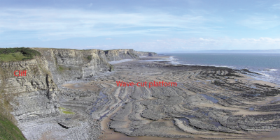
Wave-cut platforms
They are beach like coastal features slopping seaward below a cliff.
Caves
A cave is a cylindrical tunnel drilled through a cliff. It’s wide at entrance and narrow at the end. It is formed by hydraulic action, abrasion, corrasion and corrosion of waves. Examples of caves are caves are found at Lutembe beach, Tiwi beach and Kilifi in Kenya.
Blow-hole/gloup
A blowhole is hole in the ground that connects to an underground, partially submerged ocean cave. The cave and opening are shaped in such a way that when the ocean rises or waves crash into it, a jet of water and air is violently forced out through the hole.

Geo
A geo is a narrow steep sided inlet along a cliff formed when entire roof of a cave collapses.
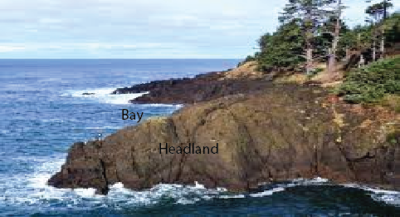
Headlands
Are hard rock or pieces of land protruding into the sea because they have resisted erosion e.g. Entebbe peninsula, Mweya peninsula along L. Victoria.
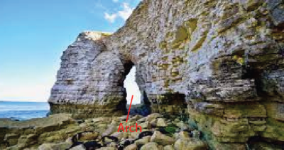
Arches
An arch is a hole or inlet that drives through a headland. It is formed when wave action attacks headland either by hydraulic action or abrasion thereby drilling a tunnel below it and leaving a bridge like feature on top
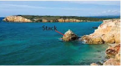
Stacks
A stack is an isolated rock feature completely detached from the mainland. It is formed when the roof of an arch on the headland collapses. Examples are rock pillar stacks near Entebbe airport, Kasenyi stack and stacks at Mombasa.
Importance of coastal features
Positive importance of coastal features
- Source of construction materials such as sand from beaches e.g. Kasenyi, Lutembe and Nabugabo along L. Victoria
- Bays and headland are used as landing sites e.g. Kasenyi and Majanji along L. Victoria
- The magnificent depositional and erosional features like cliff are tourist attraction sites.
- Mudflats along the East Africa coast (Mombasa) have mangrove forests and swamps where lumbering and crafts are done
- Bars and spits protect the coastland against floods and action of destructive waves
- Education and research.
Negative importance
- Waves bring poisonous snakes to the coast
- Strong waves cause floods
- Submerged sand bars and stumps are major causes of accidents
- Deposition of materials like snail lead to spread of diseases such as bilharzia.
Sea level changes
Sea level changes refer to the rise and fall of the sea level worldwide relative to the land or vertical movement of land relative to sea. The sea level is not static it fluctuates. A change in sea level is called eustatism. This can be positive when the sea level raises or negative where sea level falls/regresses.
Causes of sea level changes in East Africa
- Earth movements such as vulcanicity displace water and lead to rise in sea level while down warping lowers the sea floor lowering the sea level
- Freezing water on mountain top and Antarctic regions lowers the sea level while melting of ice snow on mountain top causes water to flow into the sea leading to a rise in sea level.
- Sedimentation causes a rise in sea level
- Heavy rainfall leads to a rise in sea level and evaporations causes a fall in sea level
- Global warming leads to general rise in room temperature and melting of ice on mountain tops causing a rise in sea level.
- Increase in temperature due to insolation or heat from vulcanicity causes expansion of water and rise in sea level while a fall in temperatures cause contraction of water leading to fall in sea level.
- Human activities like dumping of sewage, garbage, construction of artificial piers and Hotels on water have all led to a rise in the sea level. Over the world thousands of tones in form of hardcore stones and soils are deposited in the sea especially near: beaches to construct Hotels. In Uganda Speke Resort hotel at Munyonyo was partly constructed in Lake Victoria through a similar process.
- Rivers; the water deposited (poured) into the sea by rivers such as the Nile in Mediterranean, Tana into the Indian Ocean lead to a rise in the sea level.
- Reaction of hydrogen and oxygen; it’s believed that hydrogen atoms from the sun often enter the earth’s atmosphere and when they combine with oxygen in the ozone layer, rainfall is formed which enters into the sea to raise its level
Landforms resulting in a rise in sea level
It depends on whether they occur on highland or lowland
(i) Highland coastal areas.
Rias is a drowned river valley in highland coastal areas that remains open to the sea. They form in highland coastal areas where hills and river valleys meet the sea approximately at right angles. Examples are found at Mombasa, Dar-es-salaam, Mtwara etc
Fjords. These are submerged U-shaped glacial troughs that reach far inland. They are deep elongated and have hanging valleys and truncated spurs. They form in highland coastal areas which are affected by glaciation where glaciers erode pre-glacial valleys through plucking and abrasion. The pre-glacial valleys are deepened, widened and lengthened, transforming formerly V-shaped valleys to a U-shaped cross profile. They are deeper downwards. When drowned due to a rise in sea-level fjords are formed. Examples include: at the coastal areas of Norway, British Colombia, Chile etc.

Longitudinal Islands/Dalmatian coasts. These are straight and regular coasts, characterized by bays, sounds, where former valleys exist and peninsular and islands in areas of former hills. They form when highlands, ridges, river valleys run parallel to the coast. As the Sea – level rises, valleys are flooded and hills become chains of Islands running parallel to the coast. The resulting drowned hills are separated by parallel narrow inlets or valleys called sounds. Examples are found in Pemba, Zanzibar, Serbia, Crotia etc.

Sound is water separating the mainland from the longitudinal islands.
Peninsulas are pieces of land projecting into the sea (headlands) between bays. Valleys are drowned leaving highlands projecting sea-wards. Examples include, Entebbe peninsular, Mweya peninsular etc.
(ii) Submerged landforms in lowland coasts include.
- Estuaries are drowned/submerged river valleys in lowland areas for example at the mouth of rivers Wani and Rufigi along East African coast and R. Congo. Estuarine are formed like rias that form in highlands but estuarine form in low area.
- Creeks are narrow inlets formed by submergence of small streams e.g. Kilifi, Makupa, Chacke etc.
- Fjards are submerged large U-shaped glacial troughs that reach far inland in lowland glaciated areas. e.g.in South Eastern Sweden.
- Mud flats. Are platform of fine silt and alluvium of rivers. Sediments are deposited in shallow water, either behind shingle, bars and spits or shelter apart of estuaries and bays. Examples of Mudflats can be found at Mombasa, Lamu, Tonya etc
Landforms resulting in a fall in sea level
These include raised beaches, raised cliffs, raised terraces, waterfalls and wave cut platforms.
Importance of features resulting from sea-level changes include
Positive importance
- Rias provide natural harbor such as Mombasa.
- Raised beaches are sources of sand example Lutembe beach
- Raised beaches, terraces and cliffs promote tourism
Negative importance
- Fjords are not used for settlement or establishment of ports because they are associated with gorges and ragged terrain
- Mudflats are associated with vectors like mosquitoes, malaria, bilharzia etc.
Revision questions
- To what extent has longshore drift influenced the development of depositional features in East Africa? (25marks)
(Candidates are expected to define the term longshore drift, talk about constructive waves, give the landforms that result from longshore drift then bring out other factors. Candidates are expected to make an evaluation and bring about other factors that influence depositional features in East Africa)
- (a) Account for the occurrence of sea level changes. (10marks)
(Candidates should define the term “sea-level changes”, identify and explain the causes of sea- level changes.)
(b) Describe the land forms resulting from a rise in sea level. (15marks)
(Candidates should identify the land forms resulting from a rise in sea-level, describe their formation with illustrations. The landforms that form in highland and those that form in lowland coast area)
- Account for the formation of wave erosional coastal landforms in East Africa.
- (a) Examine the formation of wave depositional features along East Africa coast.
(b) Assess the importance of wave depositional and erosional features in East Africa.
Thank you
Dr. Bbosa Science

How can I download the work
Use top bar menu
This is exactly what I needed to read today. Water Bottle
These are good notes