
Physical geography Chapter 9: Glaciation in East Africa

Glaciation
Glaciation comes from the word ”glacier” which means moving large mass of ice from higher level to lower level under the influence of gravity leading to alteration of the terrain and carving out of unique features. Glacier exists in East Africa because of two conditions that is altitude and precipitation in form of snow or rain. High mountains above 400m (16000ft) above sea level e.g. Mt. Kilimanjaro, Mt. Kenya and Mt. Rwenzori have precipitation in form of snow. Low temperatures at such height lead to freezing of rain water culminating into formation of glacier.
Areas in East Africa where glaciers occur include Mt. Kilimanjaro, Mt. Kenya and Mt. Rwenzori
Reasons why there is limited coverage of glaciers in East Africa
- Latitude location: East Arica is astride the equator where there is high solar radiation causing high temperatures that prevent formation of ice/glacier.
- Altitude: much of East Africa is at lower altitude not exceeding 2000m. these places have temperature above the freezing point of water
- Limited precipitations in form of snow and low humidity in most parts of East Africa prevents glacial formation
- Rain shadows effect prevents glacial formation on leeward side of snowcapped mountains. E.g. there is more snow on the wind ward side of Mt. Rwenzori than on its leeward side.
- Active volcanic mountains lack glaciers due to high temperatures e.g. Mt. Elgon
- Global warming cause a general temperature rise leading to melting of ice on snowcapped mountains.
- Human activities like industrialization lead to destruction of ozone layer and consequently global warming
Processes of glacial erosion in East Africa
Movement of glacier is determined by the nature and steepness of gradient and thickness of ice. Glacier erodes the land scape to form erosion features through three processes.
- Plucking is a process by which frozen rock and any other loose fragments tear away from the rock as the glacier moves down a slope. It is most effective where there are jointed and loose rocks.
- Abrasion is the grinding process or sandpapering in which rock particles such as boulders and pebbles embedded in glacier are used as grinding tools to remove loose rock particles on the bottom and sides of glacial valley to create deep grooves
- Frost shattering involves expansion and breaking up of rocks due to extreme pressure created by freezing water/snow/ice within the jointed rocks leading to gradual enlargement of cracks into deep grooves and sometimes lakes.
- Basal sapping is the rotational slipping of ice which like landslides pivot about a point causing over deepened features like cirque.
Landforms resulting from glacial erosion include ·
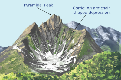
Cirque/corries
- A cirque (corrie) is a steep sided rock basin/hollow/depression with semi-circular shape cut into valley heads and mountain sides. Many are very small but some have back walls hundreds of metres high.
- Cirques usually develop from nivation hollows. Through the process of nivation, intensive shattering of highland slopes tends to produce depressions or pre-glacial hollows where ice accumulates.
- Water freezes in the hollows and thaws or melts. There is consequently expansion and contraction that breaks the rock through the process of plucking.
- The nivation hollows are widened by not only plucking but also abrasion which is the wearing process of the hollow using the materials embedded in ice.
- The back walls of the hollow are steepened by back wall recession and it is deepened by basal sapping or rotation slipping of ice in the mountain hollow.
- Debris is removed from the hollow by solifluction; creating a semi-circular basin known as a cirque.
- The depression may later be filled with water to form lakes called tarns.
- Examples include those occupied by Lac du Speke, Lac Gris, Lac Catherine on Mt Rwenzori, Teleki tarn on Mt Kenya Illustration of a cirque

Pyramidal Peaks
- A pyramidal peak is a sharp rock pinnacle which is steep sided surrounded by a system of radiating arêtes.
- It is formed from glacial erosion where cirques are first formed and the back wall recession of two or more cirques developing into the mountain head creates a sharp rock pinnacle protruding above the ice through a system of radiating arêtes.
- Since pyramidal peaks develop from radiating arêtes, which in tum develop from cirques then processes of plucking and abrasion are important in their formation.
- Examples include Margherita peak on mountain Rwenzori.
Arête
An arête is a narrow steep sided rocky ridge separating two cirques/corries.
It results from the glacial erosional process of plucking and abrasion which lead to the formation of cirques. The back wall recession of two adjacent cirques leads to the formation sharp ‘knife-like ridge called an arête separating two cirques.
Examples are found on the foothills of Mt Rwenzori, one radiating into Bujuku Valley.

Glacial trough
Glacial trough: This is a broad bottom and steep sided U- shaped valley formed when a river valley is filled with glacier. Plucking and abrasion help to deepen and widen the depression by vertical and lateral erosion. Examples include Bujuku and Mobuku valleys on Mt Rwenzori, Gorges valley on Mt Kenya and Karanga valley on Mt Kilimanjaro.

Hanging Valley
Hanging valleys. These are tributary valleys above the main valley that descend steeply into the main valley. They generally form when glacier ice deeply erodes a main or trunk valley, leaving tributary valleys literally hanging far above the main valley floor. Hanging valley streams often enter the main valley as waterfalls. Tributary valleys can be seen leading to Mobuku and Bujuku on Mt Rwenzori.

Rock steps.
These are rock projections in U-shaped valley .They are formed as a result of variation in rock resistance. Here rocks resist erosion leading to rock projections in glacial trough
Rock Basins/Ribbon lakes.
These are circular depressions in U- shaped valleys. These are formed due to unequal power of erosion due to varying thickness of ice and variation in rock resistance .They are formed where there are soft /weak/jointed rocks on floor of U- shaped valley. Examples of rock basins include those occupied by Carr lakes on Mt Kenya, L. Noir on Mt. Rwenzori and L. Michaelson on Mt. Kenya
This is a gentle sloping mass of rock on upstream side and steep irregular on downstream side. It is formed when the upstream side is smoothened by abrasion and the downstream side is affected by plucking leading to steep jagged slope. Roche Moutennee can be seen in Mobuku valley on Mt Rwenzori and in gorges valley on Mt Kenya.

Crag and Tail
Crag and Tail is a landform consisting of a rock hill and elongated tapering ridge extending downstream, which is produced by selective erosion and deposition beneath an ice sheet beyond resistant rock outcrop.

Truncated spurs.
Truncated spurs. These are spurs with steep edges ending in the valley. They are formed when former interlocking spurs are affected by plucking during glacial erosion to leave steep cliff-like valley side

Glacier landforms in lowland of East Africa
These include roche moutonnée, crag and tail, till plain, drumlin, Lateral moraine, Esker, kame Kame terrace and outwash plains
Lateral moraine
These are materials (debris) carried and deposited along the sides of the glacial trough and tend to form elongated ridges on glacial surface. When it forms, it protects the ice below from melting. Examples of lateral moraine occur at Mubuku and Bujuku troughs on Mt. Rwenzori.

Drumlins
Drumlins are oval-shaped hills about 30-50m high, largely composed of glacial drift, formed beneath a glacier or ice sheet and aligned in the direction of ice flow. They are composed o sand and little clay and occur in sort of rhythmic pattern. Examples occur in South Africa near Kimberley, and Northern European plain of Germany.

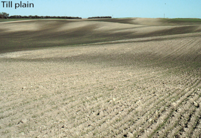
Till plain
Till plains are an extensive(wide) flat plain of glacial till that forms when a sheet of ice becomes detached from the main body of a glacier and melts in place, depositing the sediments (of boulder, clay and rock fragments) it carried. Example are found in south Africa near Kimberley particularly the Dwyka tillites
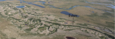
Eskers
An esker is a long ridge of gravel and other sediments, typically having a winding course, deposited by meltwater from a retreating glacier or ice sheet. Found In South Africa near Kimberly.
Importance of glaciation
Positive importance of glaciation
- Provides good scenery for tourist attraction and foreign exchange
- Source of river water and water for irrigation
- Glacial lakes such as Lac-Gris are sources of fish
- Terminal moraine boulders are used for construction and decoration
- Hydroelectricity may be generated by damming rivers
Negative importance of glaciation
- Glacial regions are associated with avalanches and landslides that cause death and destruction of man’s activities such as agriculture.
- Glaciation creates grooves and ridges that make construction of roads expensive
- Snowcapped mountains limit agriculture and human settlement
- Glacier wash cause soil erosion
Revision Questions
- Account or limited coverage of glacier in East Africa
(Define glacier and identify areas covered by glacier in East Africa. Give reasons for the limited glacier coverage in East Africa)
- Describe the formation of glacial erosional features in East Africa
(define glaciation, with examples and illustrations where possible describe the various erosional features in East Africa)
- Describe the glacier landforms in lowland areas of East Africa.
Thank you
Dr. Bbosa Science
Thanks alot for transforming Ugandan education to the next level
Thanks teacher, student 4rom stevour Christian high school nakaseke,
thanks for appreciation
Thanks teacher, astudent of teso integrated ss ngora
Thanks for being so informative. Barcelona News
Explore the detailed MBBS Fees Structure in Karnataka, covering government and private institutions.
Pursue your dream medical career at Top MBBS Colleges in Gujarat.
Enjoy exclusive benefits by applying the Raja Luck Invite Code.
Gain valuable knowledge about Raja Luck.
Find out how to Earn backlinks from trustworthy sites to boost SEO.
Enjoy unique member benefits and loyalty rewards by signing up with the Diu Win Invite Code.
Find reputable and totally managed Server Rental in Mumbai for hosting and data processing.
Access thrilling games and interesting obstacles with bdg win.
Discover fun-filled home entertainment at your fingertips with 55 club app.
Play and take on top gamers on bdg win for supreme video gaming delights.
Discover the key steps to building a successful Technology Roadmap that lines up with organization objectives.
Make notified purchases with Smart Shopping Guides that deal skilled suggestions.
This blog perfectly catches Nainital’s magic! My experience was improved by Escort Service In Nainital providing fantastic company throughout my stay.
The attention to Homemade Taste makes all the distinction.
The Best Chennai Escorts always get booked up quickly!
Searching for a Call Girl In Dehradun with great reviews.
Get all the information about **IPL 2025**, consisting of fixtures, team updates, and key match highlights.
The K-pop Shorts on https://www.youtube.com/@kpopbuzzindo/shorts are always trending for the right reasons!