
Physical geography –Map work/map reading question (UACE paper 1 question 1)

Map reading
Map work work is a compulsory number in a-level geography paper 1 and carries 25 marks.
The maps can be obtained from schools or bookshops or Communication House in Uganda. The maps are identified from sheet No., series No. and Edition
PDF of some of the maps have been uploaded while the maps in the document are reduced to a quarter the actual size.
A student requires actual map extract in the examples described below
Terminologies/technicalities
Grid references
A grid reference is a map reference indicating a location in terms of a series of vertical and horizontal grid lines identified by numbers or letters.
The vertical lines are called Eastings e.g.

The horizontal lines are called Northings e.g.

Grid references the grid reference is composed of six figure; the first three figures represent the Easting grid reference and the last three figures the Northing grid reference e.g.
Grid reference for rukonda is 354180; kyembwe is 357182; Kyembogo is 360181

Contour lines
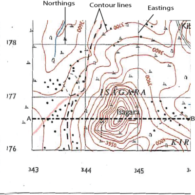
These are tiny brown line drawn on Topographical maps to show the height of region. The arrangement of contours determines the nature of landscape as follows
- Oval or circular contours represent highland, hill or Inselberg e.g. Isagra in figure above.
- Closeness of contours indicate steepness of the hill/relief i.e. when contours are very close indicate a very steep slope while spaces contours indicate gentle slope.
- Where contours don’t form a circular pattern and spaced represent low land.
- In the figure above contour lines represent points with a difference of 50 feet on the ground . thus a cross section A-B on the figure above can be represented as follows
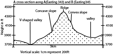
5. Contours with decreasing values towards the centre represent a valleys.
6. Vertical height/amplitude is the difference in heights of two consecutive contours for example the vertical height in the map extract above = 3750 – 3700 = 50ft
Describing relief of a map
- State the lowest contour and location
- State the highest contour and location
- Amplitude or difference between the highest and lowest contours.
- Nature of valleys i.e. broad or wide and their respective location
- Presence of conical hills, ridges, inter-locking spurs, inselbergs, and their location are indicated by very close contours.
Key
This interprets the features on a map
Scale
A scale is a ratio between distances on a map and the corresponding distance on the ground. For example, on a 1:100000 scale map, 1cm on the map equals 100000cm (1km) on the ground.
Distance on a map is obtained by measuring the distance x (in cm) between two points on a map ( for a winding road a thread may be used). The shortest distance between points on a map is obtained from the length of a straight line between the points.
Then actual distance on ground = 100000xcm or xkm
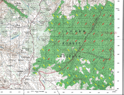
Calculating area of an irregular object on a map e.g. forest, lake, swamp,
Count the number of full of the grids X and half square Y that make up the area. (all squares that are not full are considered to be half.)
Each square grid is equivalent to 1km2

Bearings
Bearings are expressed in degrees (°) and range from 0 – 360. They are always read in a clockwise direction from the north of point to a line joining that point to another. Bearings are measured by a protractor.
Example 1
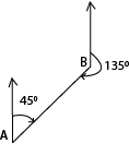
The bearing of A from B is 1350 while the bearing of B from A is 0450 (i.e. bearings are given to 3 figures)
Example 2
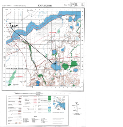
The bearing of Lake Kyamwiga (grid reference 820800) from Hipo pools (grid reference 710890) in the map below is 1300
Drawing sketch map
A sketch map should have
- title, flame/ boundary,
- compass direction
- a key (should only interpret features on the sketch map)
- marks and name features on the map but not naming on the key.
Reduction of sketch map
To draw a reduced portion of or whole map means drawing a small map i.e. the length and width of the new map are obtained by multiplying the reduction factor into the initial length and widith of the original map
Example; if the initial length and width of the map are 20cm and 30cm respectively and the reduction factor is 50%/ ½ , then the length and widith of the sketch/new map are

Thus the dimensions of reduced map will have length = 10cm and width = 15cm
- Draw the sketch map using the new measurements and then enclose it in a boundary.
- Fix or indicate the required feature in the relevant position in a fairly accurate manner.
- Indicate and label the essential features on the map drawn for example the key, title, scale and compass direction.
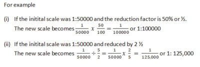
The new scale is also obtained by multiplying the initial scale and reduction factor.
Enlargement of sketch map
To drawing a enlarged portion of or whole map means drawing a bigger map relative to the initial map i.e. the length and width of the new map are obtained by multiplying the enlargement factor into the initial length and width of the original map.
Example; if the initial length and width of the map are 10cm and 15cm respectively and the enlargement factor is 200%/ 2 , then the length and width of the sketch/new map are

Thus the dimensions of reduced map will have length = 20cm and width = 30cm
- Draw the map following the above with enlarged measurements and then enclose it in a boundary.
- Fix or indicate the required feature in the relevant position in a fairly accurate manner.
- Indicate and label the essential features on the map drawn for example the key, title, scale and compass direction.
The new scale is also obtained by multiplying the initial scale and enlarged factor..
For example if the initial scale was 1:50000 and the multiplication factor is 2

Cross section/relief cross section/relief section/ line transect
It shows the nature of landscape and the features along a line drawn across two points on a map. These can be lakes, rivers, hills, forests, roads, railways, saddle, valleys, etc.
Drawing a cross section
(a) The demarcations and required features to be identified on the cross-section are stated in the question. For instance the following question refers to the map extract below and the demarcated area is indicated by dashed line.
[Draw a cross-section along Northing 76 from Easting 74 to Easting 82 and on it mark and label:
(i) any three land form features .
(ii) any two drainage features,
(iii) all weather road. (09marks)
(Also refer to Katungulu map extract)
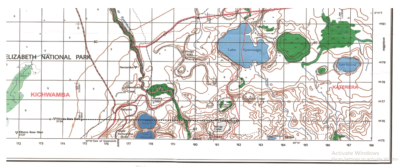
(b) Obtain the amplitude/difference between the height of the highest contour (i.e.3200ft) and the lowest contour (i.e.3900) = 3900- 3200 = 700ft and determine appropriate vertical scale.
(c) Plot each contour on the line transect to its corresponding height.
(d) Label the required features.

Settlement pattern on a map
Nuclear/clustered/grouped settlement pattern
Here houses are congested mainly in towns
Factors favoring nucleated/clustered/grouped settlement
- Economic benefit such as trade and commerce
- Presence of security
- Presence of healthy facilities
- Employment opportunities
- Government plan
- Inadequate/expensive land
- High population
Scattered/dispersal/random settlement
Houses are randomly spaced associated with rural or remote areas
Factors favoring scattered/dispersal/random settlement
- Adequate land/cheap land
- Remoteness
- Poor transport network
- Lack of formal employment
- Lack of social facilities
Linear settlement
Settlement/houses along a line such roads, railway and water body shores.
Factors favoring linear settlement
- Availability of transport
- Economic viability like trade and commerce
- Security in the area
- Presence of social facilities
NB. When explaining the factors avoid using the term “influence” because it has both positive and negative. Use terms like “encouraged”, “attracted”, “favored”.
Types of settlements on a map
- Rural/scattered found in rural area
- Urban settlement schemes found in trading centre, town
- Resettlement schemes
- Refugee camp
Drainage pattern on a map
- Radial
- Trellis
- Parallel
- Deranged
- Dendritic

Radial drainage pattern develops due to the presence of a dome or cone shaped highland such with steep slopes
Trellis drainage patterns develop due to presence of sedimentary rocks that have been folded or tilted, and then eroded to varying degrees depending on their resistance to erosion.
Parallel drainage patterns form where there is a pronounced slope to the surface of uniform rock resistance or in regions of parallel, elongate landforms like outcropping resistant rock bands.
Deranged drainage pattern (has no clear pattern) forms in areas with extensive limestone deposits, where surface streams can disappear into the groundwater via caves and subterranean drainage routes or in areas where there has been much geological disruption or areas with low relief, low slopes, and large sediment loads.
Dendritic drainage pattern (tributaries join larger streams at acute angles) develops in areas where the rock beneath the stream has no particular structure and can be eroded equally easily in all directions.
Rectangular drainage Pattern forms where the bedrock is faulted and jointed.
Physiographic regions
Physiographic region is a region having a particular pattern of relief features or land forms that differs significantly from that of adjacent regions.
Physiographic regions include lowland, upland, valley, gentle slope, flat land scape etc which can be identified from the arrangment of contours .
Upland/hilly area/ridges/iselbergs are identified from contours that are very colose
Gentle slopes are identified from contours that are moderately close
Geographic relationship
These include:-
Relationship between relief and drainage
Giving evidences from a map; state the places on a map where rivers, swamps and or lakes are located in relation to relief; for instance;
- highlands or hill in north –east have no drainage.
- Ridges in the south radial drainage patterns (river) and crater lakes.
- In central, rivers flow from a high elevation to low lands
- Rivers may be found in dry gaps or river gaps i.e. between hills/mountains
- In west rivers and swamps are in low land/valleys
Relationship between relief and transport
Giving evidences from a map; state the places on a map where roads, railway, airstrip are located in relation to relief; for instance;
- Roads are constructed along gentle slopes in the central
- Uplands and steep slopes in the north-east lack roads and railway
- The airstrip is located on low land in south-east
Relationship between drainage and transport
Giving evidences from a map; state the places on a map where roads, railway, airstrips are located in relation to drainage; for instance;
- Roads and railways cross river through bridges in the low land in the west
- Roads cross river after construction of bridges or culverts
- Lakes a crossed by use of ship, ferries, boats etc.
Relationship between drainage and settlement
Giving evidences from a map; state the places on a map where settlement occurs in relation to drainage; for instance;
- Swamps in the south are devoid of settlement
- Settlement occurs along the Lakes and rivers in the north
- Settlements are confined to well drained areas/gentle slope in the east and the central
Economic/human activities on a map
The following evidences may be sighted when stating human activities on a map
- Fishing when a map has river, lake, fish traps, fish factory, fish comparative
- Forestry when a map has sawmill, forest reserve, forest station, minor road leading to a forest
- Agriculture when a map has plantation, tea/coffee/cotton/maize factories
- Mining and quarry when a map has mine, quarry, smelter
- Manufacturing when a map has industries
- Tourism when a map has game reserve, hotels, camping sit, picnic centre, sporting activity, antiquities.
- Trade/commerce when a map has market/shops/trading centres/warehouse/custom/railway and roads
- Transport and communication when a map has has roads, railway, foot path
Functions of a place/town on a map extract.
The following evidences may sighted when stating functions of a place/town on a map extract
- Commercial centre in case the place/town has market, town, trading center, etc.
- An industrial centre in case industrial park, industry, a sawmill and ginnery
- Education centre in case the place/town has schools, institution, university
- Tourist centre in case the place/town has Hotel, waterfall, forest, forest reserve, rest house
- Administrative center in case the place/town has ADC, police station, prison
- Residential centre in case the place/town has settlements
- Transport and communication centre in case the place/town has post office and roads
- A health/ medical centre in case the place/town has a hospital, maternity centre, health unit etc.
- Religious centre in case the place/town has church, mosque and mission
- Agricultural centre in case the place/town has plantations
- Recreation centre in case the place/town has hotel, rest house
- Burial centre in case the place/town has cemetery, etc.
Possible problems faced in a place of the map
The following evidences may sighted when stating problems facing a place/town on a map extract
- Flooding in case map has low land/swamps
- Soil erosion in case map has steep slopes
- Mass wasting/ landslides in case map has steep slopes/ upland in the background.
- Wild animals that attack and threaten people in case map has forests
- Pests that cause diseases in case map has forests and planted crops.
- Diseases like malaria and bilharzia in case map has water bodies and swamps
- Vermin’s/large animal pests in case map has forests destroy people’s gardens/crops.
- Limited land for settlement in case map has steep slopes, swamps etc.
- Difficult construction of roads/communication routes in case map has steep slopes, wetlands, bridges, remoteness
- Limited land for cultivation and settlement in case map has steep slopes and bare/rocky hill tops.
Examples
The maps in the following examples have been reduced by 25%. For clarity of features download respective PDF maps from digitalteachers.co.ug or buy a print from UNEB outlet on the Communication House Kampala or from the Bookshops.
Example 3
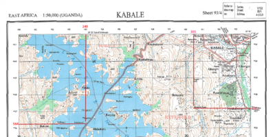
Study the East Africa, 1:50,000(UGANDA) KIBALE Map extract, part of the sheet 93/4, series Y732, Edition 4-U.S.D and answer the questions that follow
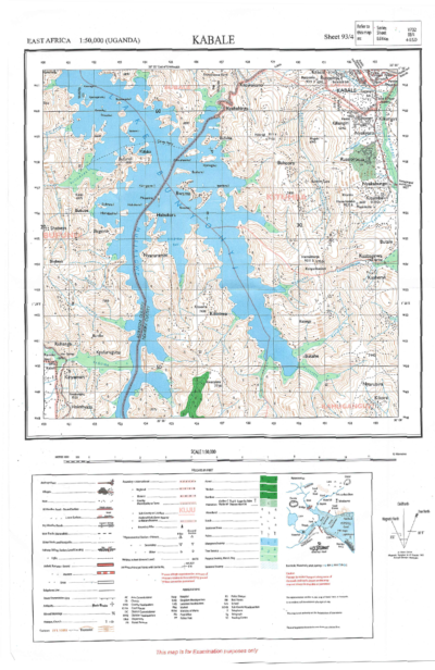
(a) (i) Identify the natural feature found at grid reference 240564 (01mark)
Habukara Island
(ii) State the grid reference of the Antiquity (Bukoora cave) South East of Bukoora. (01mark)
305573
Part for identifying feature for part (a)
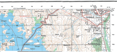
(b) Draw a relief section from grind reference 250580 to 330580 and on it mark and name
(i) any two drainage features
(ii) a saddle
(iii) any convex slope and a V-shaped valley
(iv) plantation farm (07marks)
The cross section line required is indicated by a dashed line on the map draw the cross section and compare with ours.

(c)(i) Giving evidence from the map, identify any two types of drainage patterns shown on the map extract
Radial drainage around Bufundi (210550)
Trellis drainage on R. Katenga and Karujabura
(ii) Account for the formation of any one drainage pattern identified in c(i) above
Radial drainage developed due to the presence of a dome or cone shaped highland such with steep slopes
Trellis drainage patterns developed due to presence of sedimentary rocks that have been folded or tilted, and then eroded to varying degrees depending on their resistance to erosion.
(d) With examples from the map extract, explain the problems faced by people in the area
- Flooding because of low land/swamps
- Soil erosion due to steep slopes
- Mass wasting/ landslides due steep slopes/upland.
- Wild animals that attack and threaten people from of forests such as Rwanyena
- Pests that cause diseases f in case of forests and planted crops.
- Diseases like malaria and bilharzia in water bodies (lake Bunyonyi) and swamps promote vectors.
- Vermin’s/large animal pests from forests destroy people’s gardens/crops.
- Limited land for settlement due to steep slopes and wetlands
- Difficult construction of roads/communication routes because many steep slopes, wetlands, bridges, remoteness
- Limited land for cultivation and settlement because of steep slopes and hill tops.
Find additional worked examples from the following PDF files
Physical geography advanced level map work part 1 of 3
Physical geography advanced level map work part 2 of 3
Physical geography advanced level map work part 3 of 3
Thanks
Dr. Bbosa science

The notes are good and I have understood them
Well explaindd and good sir
The explanations are all clear
It’s genuinely very difficult in this busy life too listen news
on TV, therefore I only use the web for that purpose, and obtain the latest news. https://Waste-NDC.Pro/community/profile/tressa79906983/
It’s genuinely very difficult in this busy life to listen news on TV, therefore I only use the web for that purpose, and obtain the latest
news. https://Waste-NDC.Pro/community/profile/tressa79906983/
Thanks
Thanks so much. Tomorrow am doing mock exams and geography is my first paper.This work has really helped me
I have loved the explanation however embark on new curriculum also
Looking forward to reading more. Great blog.Really thank you! Fantastic.
Your content is consistently valuable. Sports Fitness & Outdoor
Your writing resonates with me deeply. TamilBlasters Com
Choose the Top MBBS Colleges in Orissa for innovative programs and exceptional facilities in medical education.
Explore efficient enrollment pathways through MBBS Direct Admission in Manipur.
Looking for a trusted gaming site? Try Raja Luck and enjoy thrilling gameplay.