
Physical geography-Photographic interpretations(A-level)

Photographic interpretation relates to identification of features in a photograph, their description, mode formation and economic uses.
Examinable areas in photographic interpretation
(a) Drawing a land scape sketch of a photograph
A good land scape sketch should have the following
- A complete title mentioning what is required in the question (01mark)
- A frame (01 mark)
- The features asked to be shown/marked on the sketch must be labelled.
(b) Describing positions of features on a photograph
Position of feature on a photograph can be indicated as shown in the table below
| Left background | Middle background | Right background |
| Left middle ground | Middle ground | Right middle ground |
| Left fore ground | Middle fore ground | Right foreground |
(c) Types of vegetation on the photograph
These can be trees, grass, shrub
Avoid naming vegetation as savanna or tropical rainforests as much as they are likely to be so.
(d) Land uses from a photograph
There could be
- Settlement when there are houses
- Cultivation when we see crops (crop cultivation takes place in in the valley in the foreground because of fertile soil of course valleys cannot be observed in background)
- Transport when there are roods
- Animal rearing when we see animals, pasture
- Forestry when we see several trees (forest cultivation is usually on upland in the background to control soil erosion)
- Tourism for physical features like waterfalls,magnificient features like mountains, rocks etc.
- Mining and quarrying when we see quarry
- Buying and selling/trade when we see shop/hawkers with goods
- Water for domestic use in case of water body/river
- Fishing in case of water body/river
- Charcoal burnng in case of trees
- Herbs in case of vegetation
- Water for irrigation in case of in case of water body
(e) Physiographic regions/relief
These can be hill/upland, cliff, steep slopes, gentle slopes, convex slopes, concave slopes, lowland/flat land, valleys, saddles etc.
(f) Possible problems faced in a place of the photograph
- Flooding in case of low land
- Soil erosion d in case of steep slopes and exposed ground
- Mass wasting/ landslides in case of of steep slopes/ upland in the background.
- Wild animals that attack and threaten people.in case of forests
- Pests that cause diseases f in case of forests and planted crops.
- Vermin’s/large animal pests in case of forests destroy people’s gardens/crops.
- Limited land for settlement in case of steep slopes in the background.
- Difficult construction of roads/communication routes in case of steep slopes, wetlands, bridges, remotness
- Limited land for cultivation and settlement in case of of steep slopes and bare/rocky hill tops.
- Scarcity of pasture in case of poor veetation
- Poor visibility in case of mist/fog
(g) Mode of formation of common physical features
Rapids/a waterfall may formed by
-
- Differences in rock resistance where layers of soft and hard rocks laid over each other, soft rocks are quickly weathered and eroded because of steep gradient and hard rocks remain protruding in the river channel over which water drops vertically to form a water fall.
- When a river falls over a plateau edge especially when flowing from a higher level plain to lower one, a water fall forms.
- Faulting across a river bed leads to the formation of a fall at the fault line.
- Rejuvenation of a river valley forms a sharp knick point over which water flows to form a water fall.
- A tributary hanging valley entering a glacial over deepened major valley forms a waterfall
- Water flowing over resistant dykes or sills forms water falls etc.
Volcanic plug, inselbergs, tors, residual hills, outcrop rocks are formed by vulcanicity
-
- Molten magma is released into the earth crust/ onto the earth’s surface through fissures and solidifies into hard rocks as a result of radioactivity or geochemical reaction in the earth’s core.
- Prolonged denudation/weathering on the volcano wears away the softer surface leaving behind more resistant rocks.
Convex slope segments
-
- forms on the upper parts of slopes in by soil creep and rain splash erosion of hard rock that resists weathering
Concave slope segments by either
-
- depositional (e.g. talus) or transportation (e.g. pediments) slope segments that form near the base of slopes and in the absence of removal of waste (e.g. river down cutting)
- erosion of soft rocks which are easily weathered.
- Accumulation of scree due to rain wash spreads the finer particles farther than the coarser ones leading to development of concavity.
Cliff may be formed by
-
- Uplift followed by denudation/erosion/slope retreat
- Undercasting of rocks creating a vertical slope/cliff
Plunge pool
-
- It is formed denudation and erosion where soft rocks underlie a hard rock in a river channel. Through the process of corrosion, solution, hydraulic force of falling water wears of soft rock thereby widening and deepening the river channel to form a deep circular pool at the base of waterfall called a plunge pool
Lake
-
- A lake can be formed by down warping; Warping is a large scale down wards of up wards movement of an extensive area of the earth’s crust due to compression and tensional forces. The intensive in the mantle caused by radioactivity and geochemical reactions and pressure melts the rocks.
- The molten rocks move in convective currents.
- Where the convective currents converge/sink, they create a drag force that pulls the upper layers of the earth crust to sink/sag downwards (down warping thus form an extensive depression or basin.
- A lake forms when this is filled with water.
- The formed lake is characterized by an irregular shoreline, shallow, extensive with numerous islands, fresh water and extensive swamps.
Or
A lake can be formed by faulting
V-Valley/gorge is formed by erosion of steep slope by fast moving water
Formation of mist/fog
-
- Fog is formed when air at or near the earth’s surface becomes saturated by any of the three processes – cooling, addition of moisture, or mixing with another air parcel
(h) Relating relief to land use
Mention a given human activity to a particular relief type in the photograph for instance
- Lowlands in the foreground are used for animal rearing
- Lowlands in the foreground and gentle slopes in the middle ground are used for settlement
- Gentle slopes in the middle ground are used for crop cultivation
- Uplands /steep slopes in the background are used for forestry /tree planting
- Gentle slopes in the middle ground are used for forestry /tree planting
(i) Evidences that can to suggest that the planned land use in area in a photograph
These can include observation of any modern forms of agriculture, settlement or land use such as
- Terracing,
- All weather Roads
- Cattle rearing/ranching evidenced by paddocks /fence
- Keeping of Exotic/improved breeds of animals
- Settlements in planned /Grid forms /Nucleated evidenced
- Tree planting and maintenance together with hedges around settlements
- Forestry/tree planting on the steep slopes/upland in the background to conserve land
- Agro forestry e evidenced by trees planted between crops in the middle ground
(j) Area where the photograph was taken
This is answered by selecting a possible area in East Africa where similar features are found, based on physical features and human activities; for instance
- Forest/trees and road for places like marbira forest,
- Waterfalls, forests, rock area, settlement for places like Jinja, Karuma, etc
- Presence of hills with rocky tops forested slopes, settlement and agriculture in foothills etc. for places like Mubende, Kyenjojo, Kyegegwa, Nakasongola, Ntungamo, Mwanza, Arusba/Mosbi etc.
- Forested highlands, and river, boulders in the foreground for places like R. sironko in sironko, Kasese around river Nyamwamba,
- Forested highlands, and river, cliff, slip-off slope, river meandre for places like R. Rwizi in western Uganda, R. Mpanga in western Uganda, R. Ngaila in kano plain
- Diary farm, wide valleys, forested slopes/terraced hills, settlement for Kabale, Kisoro, Kenya highlands, Bushenyi, Mt, Elgon etc.
- Plugs, inselbergs for Tororo in Eastern Uganda, Kotido at Alekilek rock
Example 1
Study the photograph below and answer the questions that follow
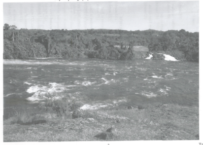
(a) Draw a landscape sketch of the area shown on the photograph and on it mark and name the following
(i) A water body/river
(ii) Rapid and waterfalls
(iii) Any two land uses
(iv) The direction of flow of the river (08marks)

(b) Describe the process responsible for the formation of either rapids or waterfall shown on the photograph.(08marks)
Formation of Rapids/a waterfall is caused by either of the following
- Differences in rock resistance where layers of soft and hard rocks laid over each other, soft rocks are quickly weathered and eroded because of steep gradient and hard rocks remain protruding in the river channel over which water drops vertically to form a water fall.
- When a river falls over a plateau edge especially when flowing from a higher level plain to lower one, a water fall
- Faulting across a river bed leads to the formation of a fall at the fault line.
- Rejuvenation of a river valley forms a sharp knick point over which water flows to form a water fall.
- A tributary hanging valley entering a glacial over deepened major valley forms a waterfall
- Water flowing over resistant dykes or sills forms water falls
(c) Outline the uses of the features shown on the photograph to the economy of the area (07marks)
-
- Forest for timber/fuel/food/wildlife
- Rapids/waterfalls for hydroelectricity generation/tourist attraction
- Water body/river for fishing/transport/recreation
- Rocks for construction
(d) Giving evidence from the photograph, suggest an area in East Africa where the photograph could have been taken. (02marks)
Jinja, Karuma, etc
Reasons
Waterfalls, forests, rock area, settlement
Example 2
Study the photograph below and answer the questions that follow
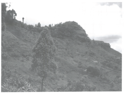
(a)Draw a landscape sketch of the area shown on the photograph and on it mark and name the following features
(i) Saddle
(ii) Cliff
(iii) Convex slope
(iv) Concave slope
(v) Conical hill
(vi) Settlement (07marks)

(b) Describe any one process responsible for the formation of any one type of slope shown in the photograph (08marks)
Convex slope segments
- forms on the upper parts of slopes in by soil creep and rain splash erosion of hard rock that resists weathering
Concave slope segments by either
- depositional (e.g. talus) or transportation (e.g. pediments) slope segments that form near the base of slopes and in the absence of removal of waste (e.g. river down cutting)
- erosion of soft rocks which are easily weathered.
- Accumulation of scree due to rain wash spreads the finer particles farther than the coarser ones leading to development of concavity.
(c) With evidence from the photograph, explain the problems faced by the people living in the area (08marks)
- Soil erosion due to steep slopes in the background and exposed ground
- Mass wasting/ landslides because of steep slopes/ upland in the background.
- Wild animals from forests attack and threaten people.
- Pests that cause diseases from forests and planted crops.
- Vermin’s/large animal pests from forests destroy people’s gardens/crops.
- Limited land for settlement due to steep slopes in the background.
- Difficult construction of roads/communication routes due to steep slopes.
- Limited land for cultivation because of steep slopes and bare/rocky hill tops.
(d) Giving reasons for your answer, suggest one area in east Africa where the photograph could have been taken
Mubende, Kyenjojo, Kyegegwa, Nakasongola, Ntungamo, Mwanza, Arusha/Mosbi etc.
Reasons:
Presence of hills with rocky tops forested slopes, settlement and agriculture in foothills etc.
Example 3
Study the photograph provided below and answer the questions that follow:
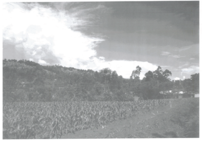
(a) Draw a landscape sketch and on it mark and name:
(i) two physiographic regions.
(ii) any four land-use (07marks)

(b) Describe the relationship between relief and land-use types in the area shown on the photograph. (06marks)
-
- Low land/ flat land in the foreground is used for agriculture
- Gentle slopes in the right middle ground are used for
- Steep slopes in the background are covered by
- Gentle slopes in the middle ground are used / favored
- Gentle slopes in the middle ground are used for erecting power transmission line
(c) Using reasons, explain any three sources of energy that are being used by people living in the areas shown in the photograph. (06marks)
-
- Wood fuel/biomass due to trees and other vegetation matter.
- Hydro/Thermo electricity evidence by mission grid/line/wires.
- Solar energy because of sunshine shown by the bright sky.
- Bio gas from the decomposing vegetation or human excreta from the settlements.
(d) ( i) With evidence from the photograph describe the problems faced by the people living in the area shown on the photograph. (04 marks)
-
- Soil erosion due to steep slopes in the background and exposed ground
- Mass wasting/ landslides because of steep slopes/ upland in the background.
- Wild animals from forests attack and threaten people.
- Pests that cause diseases from forests and planted crops.
- Vermin’s/large animal pests from forests destroy people’s gardens/crops.
- Seasonal flooding in low lands in the foreground.
- Limited land for settlement due to steep slopes in the background.
- Difficult construction of roads/communication routes due to steep slopes.
- Limited land for cultivation because of steep slopes and bare/rocky hill tops.
(ii) Giving reasons for your answer, suggest an area where the photograph could have been taken.
Mubende, Kyenjojo, Kyegegwa, Nakasongola, Ntungamo, Mwanza, Arusba/Mosbi etc.
Reasons:
Presence of hills with rocky tops forested slopes, settlement and agriculture in foothills etc.
Example 4
Study the aerial photograph provided below and answer the questions that follow.

(a)Using a tracing paper, draw a sketch of the area shown on the photograph and on it, mark and label the:
(i) river,
(ii) waterfalls,
(iii) bridges,
(iv)dam,
(v) any one industrial area,
(vi) linear settlements,
(vii) communication routes,
(viii) forested (09 mark)
(b) Explain the process responsible for the formation of waterfalls identified in (a)(ii) above. (08 marks )
Water fall is a sharp break in the channel bed over which the river falls.
It is formed where there is a fast flowing river / water over a steep slope /cliff in the youthful stage Formation of a waterfall is caused by either of the following
- Differences in rock resistance where layers of soft and hard rocks laid over each other, soft rocks are quickly weathered and eroded because of steep gradient and hard rocks remain protruding in the river channel over which water drops vertically to form a water fall.
- When a river falls over a plateau edge especially when flowing from a higher level plain to lower one, a water fall
- Faulting across a river bed leads to the formation of a fall at the fault line.
- .Rejuvenation of a river valley forms a sharp knick point over which water flows to form a water fall.
- A tributary hanging valley entering a glacial over deepened major valley forms a waterfall
- Water flowing over resistant dykes or sills forms water falls
(c) Describe the relationship between drainage and land use in the area shown on the photograph.
(06 marks)
- Roads/ railways cross the river
- Settlements are in well drained areas along the river
- Industries/factories have been constructed close to/along the river
- Bridges are constructed across the river
- A dam is constructed across the river
- Forestry is carried out in well drained areas
(d) Giving reasons for your answer, suggest an area in East Africa where this photograph could have been taken.
Possible area in East Africa where this photograph could have been taken is Jinja, Isimba in Kamuli, Karuma, Kindaruma, Hale, Kidatu
Reasons
- Permanent river with waterfalls, dams and bridges
- Settlements and industries
- Forests and farmlands
Example 5
Study the photograph provided below and answer the questions that follow

(a) Draw a landscape sketch of the area shown in the photograph and on it, mark- and label:
(i) Volcanic plug,
(ii) saddle (col),
(iii) rock strata,
(iv) cliff;
(v) concave and convex slopes,
(vi) any one vegetation type,
(vii)communication route. (09 marks)

(b) Describe the processes responsible for the formation of the stratified rocks in the (08 marks)
Processes responsible for the formation of stratified rocks
- Stratified rocks are sedimentary rocks that result from weathering of already existing rock.
- The weathered fragments are eroded and transported by agents like running water, wind to low land/valleys etc.
- This is followed by deposition of sediments and their accumulation into layers / strata separated by planes.
- Over time the layers are compressed by the overlaying weight
- Compaction and consolidation occurs letting out air and water
- The layers are later cemented and transformed into stratified rocks hence formation of sedimentary rocks.
- Explain the relationship between relief and communication in the area shown in the (06 marks)
- The road passes through the saddle in the foreground
- The road cuts through the hills or highland in the foreground
- The road passes through/ along the foothills or winds along the foot hills in the middle ground.
- The low land in the middle ground favored road construction
- The road is constructed on gentle slopes in the middle ground
- The road avoids steep slopes in the background.
NB: Candidates should tie the relationship with evidence or else no evidence no marks
(c) Explain the relationship between relief and communication in the area shown in photograph.
- The road passes through the saddle in the foreground
- The road cuts through the hills or highland in the foreground
- The road passes through/ along the foothills or winds along the foot hills in the middle ground.
- The low land in the middle ground favored road construction
- The road is constructed on gentle slopes in the middle ground
- The road avoids steep slopes in the background.
(d) Giving reasons for your answer, suggest an area in East Africa where this photograph could have been (02 marks)
Highland areas e.g. Kisoro, Kabale, Kabarole, Bundibugyo, Mbale, Kapchorwa, Moroto in Uganda. Mau ranges, Salaam, Nakuru- Naivasha area in Kenya etc.
Kilimanjaro, Amboni in Tanzania
Reasons·
Because of the presence of highlands/uplands/hilly areas.
Presence of stratified rocks in road cuttings.
Winding reads ill highland areas
Example 6
Study the photograph provided below and answer the questions that follow:
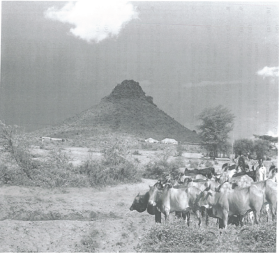
(a) Draw a landscape sketch of the area shown on the photograph and on it, mark and name:
-
- any two physiographic regions,
- settlements.
- any two vegetation types,
- bare patches of land. (07 marks)

(b) Giving reasons for your answer, account for the formation of the land form feature found in the middle background. (08 marks)
Candidates are expected to identify the feature as either Volcanic cone, Volcanic plug/ plug dome or volcanic neck/ inselbergs/ residual
- All the foregoing are a result of the main process of Vulcanicity.
- The cause or origin is due to radioactivity and That resulted in the creation of lines of weakness or passages or vents; through which either viscous; magma was intruded
- cooling and solidifying in the crust
- Weathering and erosion later exposed the intrusion which become more resistant to form an inselbergs or residual hill.
Or
- lava and ash
- Cooling and solidifying on the surface
- Denudational process acted on the extrusion forming a cone with concave upper slopes/volcanic plug.
(c) Describe the relationship between relief and land use in the area shown in the
(08 marks
- The flat/ lowland / plain land in the right foreground is used for cattle rearing.
- Gentle slopes / foot hills in the middle ground are used for settlement.
- Lowlands/ flat lands/ plain land in the right middle ground have favored the growth of trees.
(d) Giving reasons for your answer, suggest an area in East Africa where this photograph could have been (02marks)
- Karamoja region – Moroto, Kotido, Kaabong,
- Nakasongola/ Luwero
- The Teso e. Kumi – Soroti region
- Ankole – Masaka cattle corridor.
- Nyika plateau region.
- Masai steppe in Tanzania etc.
Reasons
- Presence of inselbergs/volcanic cone/plug dome/ volcanic neck.
- Presence of thorny trees/ shrubs /dry savannah.
- Cattle keeping in low lands or plains.
- Settlement on gentle slopes or foot hills.
Example 7
Study the photograph provided below and answer the questions that follow:
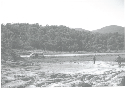
(a) Draw a landscape sketch of the area shown in the photograph and on it, mark and name:
(i) Any two physiographic regions,
(ii) any three forms of land use. (07 marks)

(b) Describe the influence of relief on land use in the area shown in the photograph. (08 marks)
- Trees/forestry on the highland/bills/ steep
- Road has been constructed on the gentle
- Agriculture/crop cultivation on the gentle slopes/lowland/valley.
(c) Giving evidence from the photograph, explain the problems faced by the people living in this (08marks)
- Soil erosion due to steep slopes in the highland in background/due to gulley/rills in the foreground.
- Difficulty in construction of roads due to steep slopes in background.
- Wild animals due to the thick forests.
- Landslides due to steep slopes.
- Limited land for agriculture due to forests/steep slopes/wasteland.
- Flooding due to the low lying area in the fore ground.
- Limited settlement because of the steep slopes.
(d) Giving reasons for your answer, suggest one area in East Africa where this photograph could have been (02marks)
- Any area in East Africa with pronounced highland, with forests c.g. Kisoro, Bundibugyo, Kabale, Rubirizi/Bunyaruguru, Mt. Elgon slopes, Aberdares etc.
Example 8
Study the photograph provided below and answers the questions which follow
(a) Draw landscape sketch of the area shown in the photograph and on it, mark and label relief features
(i) Relief features
(ii) Land use type(07marks)

(b) Describe the relationship between relief and land use in the area shown the
(08marks)
- Settlements are found on gentle slopes /foothills.
- Forests re found on the highlands /steep slopes /upland hilly areas in the Forest are also found in lowlands /gentle slopes valleys/foothills.
- Agriculture is also found in highlands /
- Roads are found on gentle slopes/ foothills.
(c) Explain the problems faced by the people living in the area shown in the
(08 marks)
- Soil erosion due to the steep slopes
- Landslides due to the steep slopes
- Limited land for agriculture due to the steep slopes.
- Difficulty in construction of roads due to steep slopes
- Flooding in valleys during the rainy season
- Dangerous wild animals such as snakes, monkeys, live in the forests
- Pests and Diseases because of the forests that are habitants;
- Limited land for settlement due to steep slopes.
- Remoteness/ inaccessibility.
(d) Giving reasons for your answer, suggest one area in East Africa where this photograph could have been (02 marks)
-
- Any area chosen which is hilly/mountainous/upland with terraces /bands such as;
- Kigezi highland.
- Mbale /Mt. Elgon areas.
- Kenya highlands.
- Slopes of Mt. Kilimanjaro.
Thank You
Dr. Bbosa Science

Am in s.4 and I need ur help
download free notes, tests, exams and marking guides from digitalteachers.co.ug
Am Aron otim Ebong ,I need your help on how to answer on geography A level on both papers
download free mote, exams and marking guides from digitalteachers.co.ug
Thank you, work well done
Am in S.6 and I need these notes sir. How can I download them
Please sir how do I get access to this work
download from digtalteachers.co.ug, use the main menu; if using a phone click the 3 horizontal lines on the top left corner of the website and follow the prompts
Thank sir
am namata juliet kakooza ineed your help in photographic interpretation
it has been a good site for me t0 study all since i loged into it but need to update on new curricullum items
Help me in photographic interpretation
You always bring something new to the table. Health & Personal Care
You’ve got a unique perspective, and I love it! 500 ka redeem code
Thanks for sharing. I read many of your blog posts, cool, your blog is very good. https://accounts.binance.com/vi/register?ref=WTOZ531Y